Delhi Master Plan 2021 has been prepared to provide regulations for development and building activity in the National Capital of Delhi.
You can download the complete report for master plan of delhi and land use map (high quality) from below. Check out the Summary of Delhi master plan 2021 below, in case you don’t have enough time to go through the complete master plan. To share your opinions and suggestions, please use the comments section at the end.
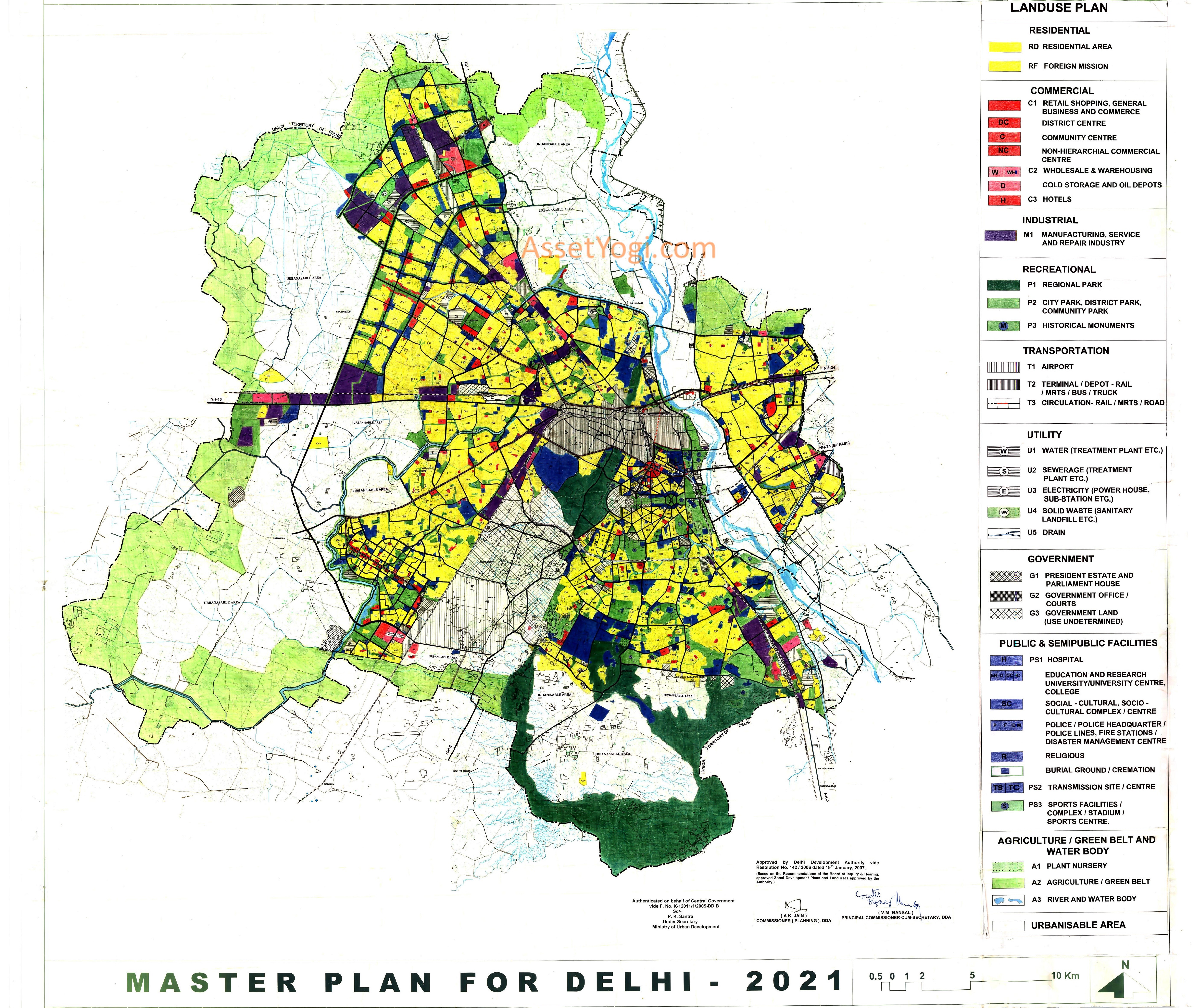
DOWNLOADS
Download Delhi Master Plan 2021 Full Report, Land Use Map and Special Area Map:
Summary – Delhi Master Plan 2021
Delhi, the political capital of India, is assuming increasing eminence among the best cities in the world. The city plays an important part in national governance, business, culture, education and sports in India.
The population of Delhi in 2001 was 138 lakh as against the Master Plan Delhi – 2001 projection of 128 lakh. This has had its inevitable implications and impact in terms of shelter, including squatter settlements, and other infrastructure facilities.
Planning for physical infrastructure, transport, ecology and environment, housing, socio-cultural and other institutional facilities is vital in developing Delhi as a world-class city. This needs a co-ordinated and integrated approach amongst several agencies involved with urban services and development along with a participatory planning process at local levels.
Below are the highlights and excerpts of Delhi Master Plan – 2021.
VISION – Delhi Master Plan 2021
Vision of Delhi Master Plan 2021 is to make Delhi a global metropolis and a world-class city, where all the people would be engaged in productive work with a better quality of life, living in a sustainable environment. This will, amongst other things, necessitate:
- planning and action to meet the challenge of population growth and in-migration into Delhi
- provision of adequate housing, particularly for the weaker sections of the society
- addressing the problems of small enterprises, particularly in the unorganized informal sector
- dealing with the issue of slums, up-gradation of old and dilapidated areas of the city
- provision of adequate infrastructure services
- conservation of the environment
- preservation of Delhi’s heritage and blending it with the new and complex modern patterns of development and
- doing all this within a framework of sustainable development, public-private and community participation and a spirit of ownership and a sense of belonging among its citizens.
POPULATION
The population assignment stipulated in the Regional Plan-2021 for the National Capital Region (NCR) and National Capital Territory of Delhi (NCTD) are as given below:
| Population Assignment – 2021 | ||
| Area | Population (In lakh) | |
| NCR | 641.38 | |
| NCTD | 220-230 | |
Source: NCR Plan – 2021.
POPULATION ESTIMATES AT FIVE YEAR INTERVALS
The population estimates for NCTD at five year intervals are given in the following table:
Five Yearly estimates of Projected Population:
| Year | Population (In lakh) |
| 2001 | 138.0 |
| 2006 | 162.0 |
| 2011 | 182.0 |
| 2016 | 199.0 |
| 2021 | 230.0 |
Source: Census of India and projections by DDA Sub-Group (MPD- 2021)
DELHI URBAN AREA-2021
In 2001, about 702 sq km of area was estimated to have been built up, accommodating about 138 lakh population. In order to accommodate the projected population of 230 lakh by the year 2021, a three-pronged strategy is recommended in delhi master plan 2021:
- Encourage the population to deflect in the NCR towns;
- Increase the population holding capacity of the area within existing urban limits through redevelopment; and
- Extend present urban limits to the extent necessary.
POPULATION HOLDING CAPACITY OF DELHI
The area within the existing urbanisable limits of Delhi Urban Area-2001 consists of the planning zones A to H and the Dwarka, Rohini, Narela Sub-city projects. Population holding capacity of A to H zones is to be enhanced through a redevelopment strategy and modified development norms.
Zonewise Estimated Holding Capacity of Existing Urban Area:
| (Population in ‘000) | |||
| Zone | Holding capacity | Existing population | Holding capacity |
| MPD 2001 | 2001 | 2021 | |
| A | 420 | 570 | 570 |
| B | 630 | 624 | 630 |
| C | 751 | 679 | 788 |
| D | 755 | 587 | 813 |
| E | 1789 | 2798 | 2800 |
| F | 1278 | 1717 | 1975 |
| G | 1490 | 1629 | 1955 |
| H | 1865 | 1226 | 1865 |
| Sub total | 8978 | 9830 | 11400 |
| Dwarka | 597 | 1300 | |
| Rohini III | 96 | 160 | |
| Rohini IV & V | 198 | 820 | |
| Narela | 179 | 1620 | |
| Sub total | 3222 | 1070 | 3900 |
| GRAND TOTAL | 122 Lakh | 109 lakh | 153 Lakh |
Note: Population figures are only broad planning guidelines.
The remaining population for the year 2021 will have to be accommodated in the planned new urban extensions.
URBAN EXTENSION
Out of the remaining 77 lakh (230-153 lakh) population, 29 lakh already exists in villages, census towns, unauthorised colonies and JJ clusters in the present rural areas. Therefore about 48 lakh additional population is to be accommodated in the future urban extensions.Land in the Urban Extension is proposed to be broadly distributed in different land uses in the following manner as shown in Table.
| Land use Distribution | ||
| Land use | % of Land | |
| Residential | 45-55 | |
| Commercial | 4-5 | |
| Industrial | 4-5 | |
| Green/Recreational* | 15-20 | |
| Public & Semi-Public Facilities | 8-10 | |
| Circulation | 10-12 | |
*This does not include green areas within the various gross land use categories.
As per delhi master plan 2021, on an average the space required per person would be 40 sqm, covering about 920 sqkm of urban area for the projected population of 230 lakh in year 2021.
SHELTER & HOUSING POLICY – DELHI MASTER PLAN 2021
The policy regarding “Shelter” is based on the goal of ensuring ‘Shelter for All’ by harnessing the potential of the public, private / corporate and household sectors. It aims to ensure effective housing and shelter options for all citizens, especially for the vulnerable groups and the poor, by creation of adequate housing stock on either rental or ownership basis. It envisages the role of the public agencies as facilitator through policy and strategic interventions.
CONTROL FOR BUILDING/ BUILDINGS WITHIN RESIDENTIAL PREMISES
Residential Plot-Plotted Housing
Maximum ground coverage, FAR, number of dwelling units for different size of residential plots shall be as per the following table:
| Area of Plot (sq. m) | Max. Ground | FAR | No. of DUs | |||
| Coverage % | ||||||
| 1 | Below 32 | 90* | 350 | 3 | ||
| 2 | Above 32 to 50 | 90* | 350 | 3 | ||
| 3 | Above 50 to 100 | 90* | 350 | 4 | ||
| 4 | Above 100 | to 250 | 75** | 300** | 4 | |
| 5 | Above 250 | to 750 | 75 | 225 | 6 | |
| 6 | Above 750 | to 1000 | 50 | 150 | 9 | |
| 7 | Above 1000 to 1500 | 40 | 120 | 9 | ||
| 8 | Above 1500 | to 2250 | 40 | 120 | 12 | |
| 9 | Above 2250 | to 3000 | 40 | 120 | 15 | |
| 10 | Above 3000 | to 3750 | 40 | 120 | 18 | |
| 11 | Above 3750 | 40 | 120 | 21 | ||
Notes:
- The local body concerned shall be competent to disregard variation of upto 2% in plot size, arising from conversion of area from sq. yard to sq.m. and to grant the norms applicable to the lower category of plot size in accordance to para (ii) below.
- *100% ground coverage shall be eligible for regularization of construction, already existing as on 22.09.06 on payment of charges as notified.
- Minimum size of the residential plot shall be 32 sqm. However, in case of Government sponsored economically weaker section schemes, size could be reduced further.
- **100% ground coverage and 350 FAR shall be eligible for regularization of construction already existing as on 22.09.06 on payment of charges as per the notification, in respect plot size between 100 to 175 sqm.
- Permissible FAR and Dwelling Units shall not be less than MPD-2001 norms.
Terms and Conditions:
Following terms and conditions are applicable for residential development as per delhi master plan 2021.
Additional Dwelling Units
The additional number of dwelling units would be subject to payment of levy for the augmentation of civic infrastructure.
FAR
The total coverage and FAR permissible in any plot in a category, shall not be less than that permissible and available to the largest plot in the next lower category.
The mezzanine floor, and service floor, if constructed, shall be counted in the FAR.
Height
The maximum height of the building in all plots shall be 15 metres.
Subdivision
Subdivision of plots is not permitted. However, if there are more than one buildings in one residential plot, the sum of the built up area and ground coverage of all such buildings, shall not exceed the built up area and ground coverage permissible in that plot.
Basement
Basement shall not be counted towards FAR if used for purposes permissible under Building byelaws namely household storage and parking. Area of basement shall not extend beyond the coverage on the ground floor as per permissible and sanctioned built up area, but may extend to the area below the internal courtyard and shaft.
Basement if used in terms of Chapter 15.0, mixed use regulations shall count towards FAR and shall be liable to payment of appropriate charges, if it exceeds the permissible FAR.
Stilts
If the building is constructed with stilt area of non-habitable height (less than 2.4m), used for parking, such stilt area shall not be included in FAR but would be counted towards the height of the building.
Parking
Parking space shall be provided for within the residential plot as follows:
- 2 Equivalent Car Space (ECS) in plots of size 250-300 sq.m.
- 1 ECS for every 100 sq.m. built up area, in plots exceeding 300 sq.m., provided that, if the permissible coverage and FAR is not achieved with the above-mentioned parking norms in a plot, the parking norms of the preceding category shall be allowed.
Density
For the purpose of density calculations, the dwelling unit shall be considered to accommodate 4.5 persons and the servant quarter to accommodate 2.25 persons.
Setbacks
The minimum setbacks shall be as given in the following table:
| S.No. | Plot size (in sq.m.) | Minimum Setbacks (in metre) | ||||
| Front | Rear | Side(1) | Side(2) | |||
| 1 | Below 100 | 0 | 0 | 0 | 0 | |
| 2 | Above 100 | and upto 250 | 3 | 0 | 0 | 0 |
| 3 | Above 250 | and upto 500 | 3 | 3 | 3 | 0 |
| 4 | Above 500 | and upto 2000 | 6 | 3 | 3 | 3 |
| 5 | Above 2000 and upto 10000 | 9 | 6 | 6 | 6 | |
| 6 | Above 10000 | 15 | 9 | 9 | 9 | |
In case the permissible coverage is not achieved with the above-mentioned setbacks in a plot, the setbacks of the preceding category may be allowed.
In the case of construction in the future, a minimum 2m x 2m open courtyard shall be provided for in residential plots of area of 50 sqm. to 100 sqm.
Servant Quarters
Number of servant quarters shall be provided as per approved layout plan and shall be constructed within the stipulated height. However, if the garage block space is merged with the main building, no separate servant quarter block or servant quarter, as part of main building shall be allowed. However, provision for a servant’s room as part of the dwelling unit within the permissible coverage FAR shall be allowed.
Each servant quarter shall comprise of one habitable room of area not less than 11 sqm. floor area, exclusive of cooking verandah, bathroom and lavatory. The maximum size of servant quarter shall be 25 sqm. If larger in size, the servant’s quarter shall be counted in density as a full dwelling unit.
Additional FAR
Plot owners / allottees seeking extra coverage, additional floor or part thereof, over and above Gazette Notification dated 23.07.98, as per above mentioned norms shall be charged betterment levy (or additional FAR charges) at the rates notified with the approval the Government from time to time. This is in addition to the levy payable on the additional FAR allowed vide notification dated 23.07.98 and over the FAR allowed vide notification dated 15.05.95.
Plot owners / allottees seeking regularization of construction in terms of the additionalcoverage allowed under this notification, shall have to pay a penalty and compounding charges notified with the approval of the Government, over and above the betterment levy referred to in para (xiii) above.
Additional Height
Plot owners / allottees seeking regularization of additional height in terms of this notification, will have to pay penalty and special compounding charges notified with the approval of the Government, in addition to betterment levy referred to in para (xiv).
The amount so collected be deposited in an escrow account by the local body concerned for incurring expenditure for developing parking sites, augmentation of amenities / infrastructure and environmental improvement programmes and a quarterly statement of the income and expenditure of the account shall be rendered by the local bodies to the Government.
Encroahment
1[Enroachment on public land shall not be regularized and shall be removed before the local body grants sanction for regularization of additional construction or height except the following :-
- Projections / chajjas / covered chajjas built up portion which existed before 7.2.2007 upto 1m above 3m height from the ground level shall be regularized for plot size upto 175 sqm on roads below 24m ROW in pre-1962 colonies (except for A & B category), in unplanned areas (including special area, village abadi and unauthorized regularized colonies) and re-settlement colonies. The owners / occupiers shall have to obtain structural safety certificate and fire clearance within a reasonable period of time as notified by the Government. Such projections / built up portion thereon shall be counted in FAR and in case of excess FAR over and above permissible FAR, such FAR in excess shall be regularized subject to payment of appropriate charges as approved by the Government.
- The local body concerned shall carry out a survey within a period of two months from the date of notification of all such projections eligible to be regularized and put such list in public domain for objections from the occupiers / owners and any person of the public against inclusion / exclusion of such projection in the list and the list thereafter will be finalized within a period of one month after considering such objections received in writing.
Regularization
Every applicant seeking sanction or regularization of additional FAR and / or height shall submit a certificate of structural safety obtained from a structural engineer. Where such certificate is not submitted or the Building is otherwise found to be structurally unsafe, formal notice shall be given to the owner by the local body concerned, to rectify the structural weakness within a reasonable stipulated period, failing which the building shall be declared unsafe by the local body concerned and shall be demolished by owner or the local body.
Standard Plans
There are a number of standard building plans designed and approved by the Authority. Such plans shall continue to operate whenever applicable. Such plans shall be modified as per the applicable development controls.
Ref : DDA