Faridabad Master Plan 2031 has been prepared to provide regulations for development and building activity in the industrial town of Faridabad in Haryana. It envisages a population of 38.86 lakhs by 2031 and accordingly 34,368 hectares of land is provided under the proposed land use by 2031 in faridabad master plan.
You can download the proposed land use maps from below. Check out the Summary of Faridabad master plan 2031 below. To share your opinions and suggestions, please use the comments section at the end.
Downloads
Download Draft Faridabad Master Plan 2031 Map, government notification (pdf), unofficial coloured layout plan and official Faridabad Master Plan 2011 Map:
-
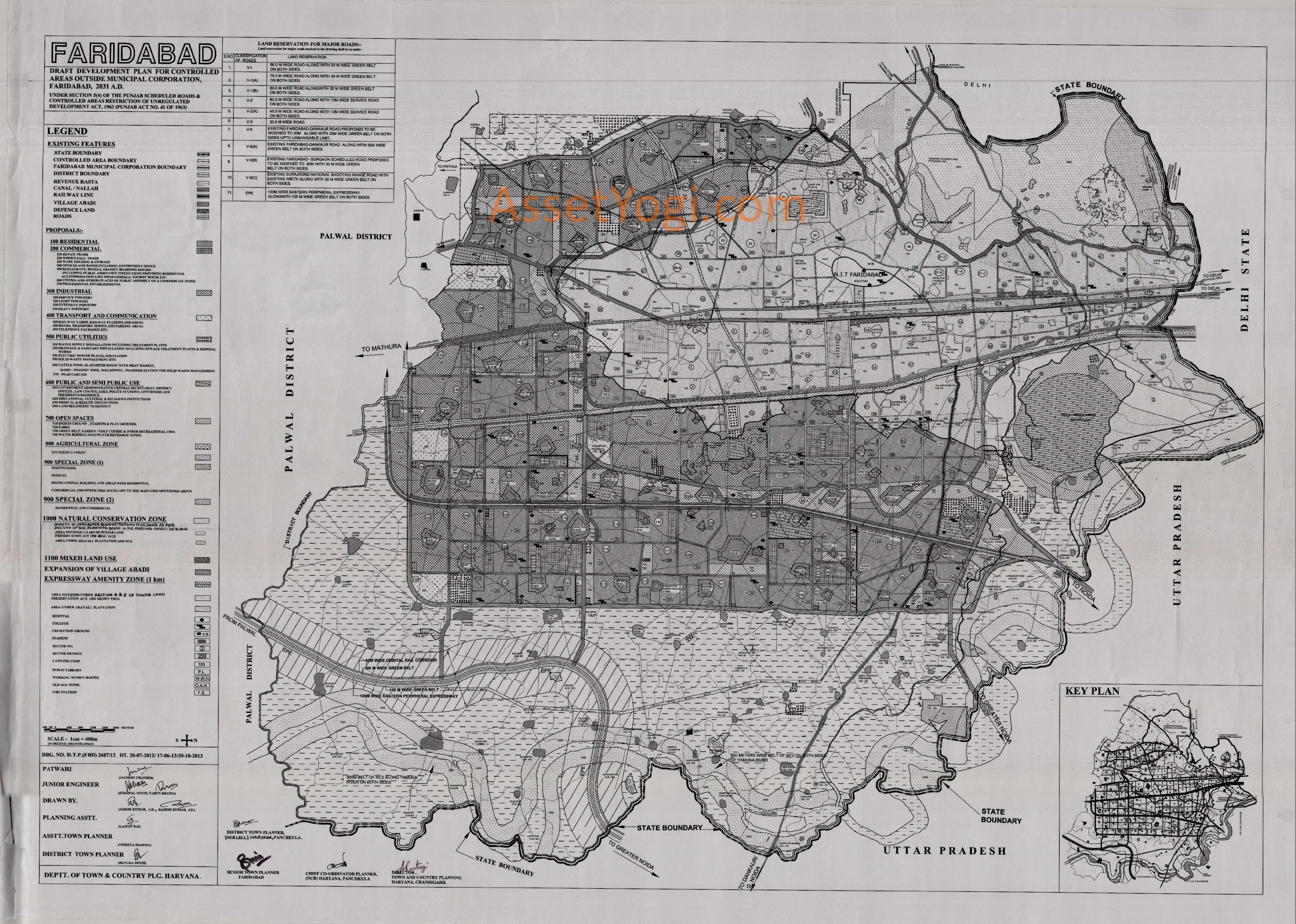
Draft Plan 2031 – Map
-
Notification – PDF
-
Faridabad Layout Plan – Color (Reference)
-
Master Plan 2011 – Map
Summary – Faridabad Master Plan 2031
Introduction
Faridabad is the largest city in the north Indian state of Haryana, in Faridabad district. It is a leading industrial center and situated in the National Capital Region (India) near the Indian capital New Delhi. It is located between Delhi, Noida, Greater Noida and Gurgaon.
Faridabad enjoys a prime location both geographically and politically. Faridabad-Ballabgarh Complex is situated on Delhi-Mathura road (NH-44) at a distance of 32 KM from Delhi. It is one of the largest agglomerations consisting of three towns, namely Faridabad Old, Ballabgarh and N.I.T. Faridabad.
This complex, being within 32/40 KM radius of Delhi, is one of the recommended Metro towns of N.C.R. The river Yamuna forms the eastern district boundary with Uttar Pradesh. The newly developed part of Faridabad (Sec. 66 to 89) between Canal and Yamuna is commonly referred as Neharpar or Greater Faridabad. The Delhi-Agra National Highway No.2 (Sher Shah Suri Marg) passes through the centre of the district.
Faridabad is also a major industrial hub of Haryana. 50% of the income tax collected in Haryana is from Faridabad and Gurgaon. Faridabad is one of the most populated and industrialized cities of Haryana. The city is famous for Henna production in agriculture sector while tractors, motor cycles, switch gears, Refrigerators, shoes & tyres are other famous industrial products of the city.
Availability of Infrastructure
Faridabad is well connected by a network of road and electricity. All the villages of the district are connected by metalled roads and have electricity since 1970. Faridabad is well connected with other parts of the country by Rail and Road. The broad gauge Railway line of Northern and North-Central Railway pass through the district and most of the trains going to South and West of India pass through the District. Also, Delhi-Mathura-Agra road (NH-44) passes almost through the middle of the district. Faridabad and Ballabgarh are the main towns of the district.
Economic base of the town/functional status
Faridabad is home to one of the largest industrial estates of Asia, which houses a large number of manufacturing industries. Economy of Faridabad is largely dependent on industry.
The total number of small, medium and large industries in district Faridabad is about 15,000 which provide direct and indirect employment to nearly half a million people and ranks as the 9th largest industrial estate in Asia. The place is home to many international/multinational companies namely; Whirlpool, Goodyear, Larsen & Toubro, Escorts, Eicher, Cutler Hammer, Hyderabad Asbestos and Nuchem etc.
Within NCR, Gurgaon and Noida have been in the forefront in attracting investments, which have been primarily in the information technology (IT) and bio-technology (BT) sectors. Faridabad has lagged behind in these sectors and is now gearing up to catch up with Gurgaon and Noida. More and more investments are flowing into various sectors of industry, commerce and real estate.
Keeping in view the above, land use proposals have been formulated on the consideration that industrial activities and trade and commerce will continue to remain the major economic base of the town. The town is growing as a major industrial centre of the State as well as of the region. The Haryana State Industrial and Infrastructure Development Corporation has already acquired land and developed an Industrial Modal Township (IMT) on the eastern side of the Agra Canal. A lot of industrial activities have already come up in the controlled areas after obtaining the change of land use permissions from the competent authority.
Population/demography
The growth trend of the population in the area covered under this plan has been given in the following table along with the projections upto the perspective period:
| Year | Population | Growth Rate (%) | ||||
| 1961 | 59,039 | – | ||||
| 1971 | 1,22,817 | 108.03 | ||||
| 1981 | 3,30,864 | 169.40 | ||||
| 1991 | 6,17,717 | 86.70 | ||||
| 2001 | 10,55,938 | 70.94 | ||||
| 2011 | 14,38,855 | 36.26 | ||||
| 2021* | 24,38,000 | 69.44 | ||||
| 2031* | 38,86,407 | 59.41 | ||||
| Source: Census of India | ||||||
| * Projected Population | ||||||
As per the above figures it is clear that there is a descending trend of population in Faridabad for the last 20 years. It is also a fact that the area notified in the Final Development Plan of Faridabad-Ballabgarh Complex 2011 AD (on the eastern side of the Agra Canal) is still developing.
However, in the forthcoming decades, the likely implementation of various infrastructure projects such as Metro Rail, Dedicated Freight Corridor and Eastern Peripheral Expressway, shall provide a boost in the growth of this town. In the Regional Plan 2021 AD of NCR, the population of Faridabad town has been projected as 25 lacs (approx.) by 2021 AD with a variation of +2.5%.
Extension of Urbanizable Proposals
For a projected population of 10 lacs for the year 2001, a draft development plan was published-vide Gazette notification No. 3431-10DP-82/6194 dated the 26th April, 1982. Thereafter, the Final Development Plan of Faridabad-Ballabgarh Controlled Areas 2011 A.D. was published vide Haryana Government Gazette notification No. 13/29/91-3CII dated 11th December, 1991 for a projected population of 17.5 lacs by 2011.
This Plan had proposals for urbanization from Delhi border in the North, up to Foothills of Aravalli ranges in the West, beyond Gurgaon-Agra Canal in the East and upto the revenue estate of village Jharsently in the South.
The length of the urbanizable area in the Final Development Plan of 2011 is about 24 Kms. and width 12 Kms. Towards western side of the above urbanizable area, there is a rocky undulating area, wherein urbanization is not feasible. Similarly, this town cannot be expanded towards its north due to the constraint of Haryana-Delhi border. Therefore, the additional area beyond east of Agra Canal, south and South-West of the town is being proposed for the development of additional urbanizable area for additional population in Faridabad Master Plan 2031.
Extent of various Land uses
The Draft Faridabad Master Plan 2031 has been proposed, keeping in view, the overall town density of 113 persons per hectare, to accommodate 38.86 lacs persons by 2031 A.D., within the urbanizable area of 34368 hectares. The extent of various land uses is described as below: –
| Sr. No. | Land Use | Total area (in hectares) | Percentage |
| 1 | Residential | 14328 | 41.69 |
| 2 | Commercial | 2069 | 6.02 |
| 3 | Industrial | 6179 | 17.98 |
| 4 | Transport & Communication | 4020 | 11.7 |
| 5 | Public Utility | 638 | 1.86 |
| 6 | Public & Semi Public Uses | 1299 | 3.78 |
| 7 | Open Spaces, Parks & Green Belts | 5314 | 15.46 |
| 8 | Special Zone | 448 | 1.3 |
| 9 | Mixed Land Use | 73 | 0.21 |
| Total | 34368 | 100 |
Residential
An area of 14328 hectares has been proposed for residential purpose on the basis of average residential density of 271 persons per hectare (PPH). The density for the proposed residential sectors has been kept as 300 persons per hectare to accommodate the projected population.
Three sectors bearing nos. 119, 143 and 146, adjoining to the proposed industrial sectors have been proposed with a density of 600 PPH, wherein only group housing projects will be permitted. Eight pockets of 25 hectares each have also been reserved for high density development of 1125 PPH in sectors 99, 112, 119, 122, 139, 143, 146 and 156, paving the way for construction of smaller flats and for providing housing to low and medium income group.
The Government decision regarding increase in the sector density has been incorporated in the plan with the following provisions: –
- The additional area for infrastructure shall be provided in the already planned/developed residential sectors to meet out the requirement of the additional population.
- The minimum width of the roads in a residential colony/sector shall not be less than 12 metres.
- The minimum area for parks/open spaces in a residential colony/sector shall be planned in such a manner that it shall meet the minimum norm of 2.5 sq. metres per person.
Commercial
An area of 2069 hectares, has been proposed for commercial purpose. There is a tendency of converting existing residential areas into commercial areas along the major roads. Therefore, in the present plan, commercial land uses have been proposed along major roads in a linear pattern along sector roads between various sectors so that tendency of converting residential areas into commercial use can be curbed.
In addition, sector 100, 120 and 154 have been proposed as city centre. As per the approval conveyed vide Govt. memo no. 13/66/03-3KII dated the 30th September, 2003, a 70 metre wide strip of land in sector 20A and 20-B facing Delhi-Mathura road has been converted from Public and Semi Public use to Commercial. The land use of sectors 27A, 27B, 27C and 27D and the existing industrial belt along Delhi-Mathura Road (NH-44) upto a depth of 200 metre in sector 32, 35 and 36, after leaving 50 metres wide restricted belt along NH-44, has been converted into commercial land use.
However, the land use of industrial plots, already allotted by any government agency in this area, shall be retained and shall only be changed with prior permission of competent authority. The commercial sector 100 and 117-A have been reserved for exclusive development by HUDA.
Industrial
Since, Faridabad is primarily an industrial agglomeration; an area of 6179 hectares has been proposed for industrial development in the present plan. The existing Gas based Thermal Plant has already been accommodated in the Development Plan as special zone. HSIIDC has already developed an Industrial Model Township (IMT) in sectors 66, 67, 68 and 69 situated in the east of Agra Canal.
Due to the existence of industries in sector 13, the land use of sector-13 has been changed from institutional to industrial-cum-institutional. A width of 60 metre to 120 metre, around the village abadies falling in the proposed urbanizable zone has been reserved in the Master Plan for the future development of this area which shall be regulated as per the policy framed by the Government from time to time.
Provision of multi-level parking for each 100 acres urbanizable area and other small town level infrastructure facilities such as site for Telephone Exchange, site for Transit Station for Solid Waste Disposal, site for Rain Basera etc. will be provided at the time of preparation of the circulation plans of the respective sectors.
Transport & Communication
Circulation Pattern
For smooth channelization of inter-city traffic, the circulation pattern proposed in the Faridabad Master Plan 2031 is as under:
Delhi-Mathura Road (National Highway No. 44)
This road continues to be the central axis for the Inter-State traffic to Delhi and Uttar Pradesh. It also carries the major portion of Intra-city volume of traffic, resulting in lot of congestion on this road. To relieve this road from the external traffic, a 60 metre wide bypass road has been constructed by HUDA, as per the provisions of published Final Development Plan-2011 A.D.
In addition to the already proposed 75 metre wide eastern peripheral road in the Final Development Plan 2011 A.D, 75 metre wide roads and 90 metre wide road have been proposed for the additional urbanizable area proposed in the eastern side of Agra Canal, which will connect the existing roads and also to the proposed urbanizable area of Prithla, Noida and Greater Noida.
Eastern Peripheral Expressway
A 100 metre wide road, known as Eastern Peripheral Expressway, has been proposed alongwith 100 metre wide green belt on both sides in the Faridabad Master Plan 2031. Two links with 75 metre width have been proposed to connect this expressway near sector 121 and sector 132.
The connectivity proposed near sector 131 and 132 has been proposed to facilitate the industrial sectors which shall be developed by HSIIDC and the same shall not be included in the External Development charges to be fixed by HUDA.
Intra-city Road Network
For intra-city traffic a network of 60 metres wide roads, alongwith 12 metre wide service roads, spread at a distance of about1 kilometre to 1.5 kilometres apart on the gridiron pattern have been proposed.
These roads are the sector dividing roads, which have been shown as V-2 on the present Plan. Within each sector, road network of 24 metres and 12 metres width shall be adopted while preparing the detailed layout plan of each sector.
Over Bridge/Under pass on Railway Line
For proper linkages of urbanizable proposals on eastern and western side of the Railway line, it is necessary to have Railway Bridges.
In addition to the already proposed Railway Over Bridges, over the level crossing on Mewla-Maharajpur and Sarai Khawaja-Suraj Kund Road, one Railway over bridge has been proposed on the crossing of 75 metre wide eastern peripheral road with the Delhi-Mathura Railway line near village Malerna.
Bridge over Gurgaon and Agra Canals
The present bridges on Agra Canal are very old and weak which were designed to carry the rural traffic. To integrate the urbanizable proposals on either side of Agra and Gurgaon Canals, bridges on sector dividing roads have been proposed.
The existing bridges near old Faridabad, Tigaon road, Palla road and Ballabgarh-Mohna Road require widening and strengthening.
Dedicated Freight Corridor
The Dedicated Freight Corridor from Mumbai to Dadri will be passing through the proposed urbanizable area. A 50 metre wide green belt has been proposed on both sides of the Dedicated Freight Corridor and in this 50 metre wide green belt, 12 metre wide service road has been proposed on both sides.
Connectivity to Noida and Greater Noida
Two linkages from the outer peripheral road, near sector 92 and near sector 95 have been proposed for providing connectivity to Noida and Greater Noida respectively.
Metro Connectivity
The Metro rail has also been proposed along Delhi-Mathura road, up to Ballabgarh. This is presently being implemented by Delhi Metro Rail Corporation.
Apart from it, under faridabad master plan 2031, extension of this link upto village Sikri has been proposed as well as along the bypass road along Gurgaon/Agra Canal and along 75 metre wide road along sectors 87, 88, 89, 84, 83, 78, 77, 72, 71, 68, 67 and 66, which however shall be subject to change as per feasibility and other studies to be conducted subsequently.
Regional Rail Network
In accordance with the proposals of Regional Plan 2021 A.D. of NCRPB, the provision of Regional Rapid Transit System along the existing Delhi-Mathura Railway line has also been made. Further, Regional Plan provides for Inner Regional Orbital Rail Corridor (IRORC) to connect Sonepat-Jhajjar-Gurgaon-Faridabad-Dadri-Meerut-Baghpat-Sonepat.
As described above, the circulation system of the town shall have Gridiron System. In addition to the already proposed Transport Zone of the Final Development Plan-2011 A.D, Transport Nagars/sites have been proposed near proposed industrial sectors along main roads. An area of 4020 hectares has been proposed for Transport and Communication.
Road Heirarchy
For smooth movement of traffic in the proposed urbanizable area, an integrated system of transportation and road network has been provided. The hierarchy of the right of way of major roads has been proposed as under:-
| Sr. No. | Classification of roads | Land reservation |
| I | V-1 | 90 metre wide road with 30 metre green belt on both sides. |
| II | V-1 (A) | 75 metre wide road with 30 metre green belt on both sides. |
| III | V-1 (B) | 60 metre wide road with 30 metre wide green belt on both sides. |
| IV | V-2 | 60 Metres wide road along with 12 metre wide service road on both sides. |
| V | V-2 (A) | 45 metre wide road along with 12 metre wide service road on both sides. |
| VI | V-3 | 30 metre wide road |
| VII | V-6 | Existing Faridabad-Dankaur road widened to 30 metre along with 30 metre wide green belt on both sides up to urbanizable limit. |
| VIII | V-6 (A) | Existing Faridabad-Dankaur road from urbanizable limit to U.P. Border along with 30 metre wide green belt on both sides. |
| IX | V-6 (B) | Existing Faridabad-Gurgaon scheduled road widened to 90 metre with 30 metre wide green belt on both sides. |
| X | V-6 (C) | Existing Surajkund-National Shooting Range road with existing width with 30 metre wide green belt on both sides. |
| XI | Eastern Peripheral Expressway | 100 metre wide Eastern Peripheral Expressway alongwith 100 metre wide greenbelt on both sides. |
Transportation Hubs
One Transport Nagar has already been planned in sector 61. Additional, Transport and Communication areas have been proposed in different parts of the town depending on the future demand. Also, as per faridabad master plan 2031, site of Inter State Bus Stand has been proposed in sector 12 which has already been transferred to the Transport Department. As per the future requirements, new Bus Terminal may be proposed in the proposed Transport and Communication zone.
Public Utility
In the faridabad master plan 2031, all existing public utility sites have been accommodated. Similarly, the sites of sewage disposal have been proposed in the area of east Agra Canal. A total area of 638 hectares has been proposed for public utility purposes.
In the new urbanizable area, suitable sites for 400 KV and 220 KV substations have been allocated for the development of required infrastructure for transmission and distribution of electricity in consonance with the requirement of HVPNL.
The site of solid waste disposal of Gurgaon and Faridabad has been provided in the revenue estate of village Bandhwari in district Gurgaon. For additional required sites for solid waste disposal, disposal of silt/debris, medical waste and for carcasses, four sites have been proposed i.e. three on the eastern side and the other on the western side of the urbanizable area of the town. In addition to these sites, area has also been exclusively earmarked for the purpose of cattle pond, slaughter house with meat market, dairy, piggery zone and Dog Kennel.
Public and Semi Public Uses
Under this use, an area of 1299 hectares has been proposed in linear pattern along major roads. The neighborhood level community facilities will be provided while preparing the layout plan of individual sector.
However, for public and semi public use, the town level facilities, which include colleges and Hospitals, have been proposed in the Faridabad Master Plan 2031. The Colleges and Hospitals have been proposed considering the projected population of 38.86 lacs.
Open Space
In faridabad master plan 2031, an area of 5314 hectares has been kept under this use. Out of this, major open spaces lie along major roads, along Dedicated Freight Corridor and between the industrial and residential area, in the form of green belts/green buffers.
The green area along Tilpat Firing Range, Air force Station, Badkhal and Surajkund Tourist Complex and along 75 metre wide road on the eastern side have been proposed in the master development plan of faridabad (2031). An area measuring approximately 1000 acres, has been proposed for development of golf course(s) towards the northern side of V-1 road along sector 92, 93, 94 and 95.
One town level green area already exists in sector 12. Central Park shall be developed in the open space zone proposed along the eastern peripheral road of Final Development plan 2011 A.D.
Special Zone
Special Zone-1
This zone already exists in the published Final Development Plan 2011 A.D. As already provided in the published Final Development Plan, this zone shall include institutions, offices, recreational building and areas with residential, commercial and other uses ancillary to the main uses mentioned above, provided that the gross area under each main use shall not be less than 10 acres. However, most of this area is presently under the area notified under section 4 & 5 of the Punjab Land Preservation Act, 1900.
Special Zone-2
In addition to special zone-1, another special zone i.e. special zone-2, has been proposed in the Faridabad Master Plan 2031 for residential and commercial uses, which was basically the land of HPGCL near village Mujessar.
Mixed land use
The commercial belt proposed in Final Development Plan (FDP) Faridabad-Ballabgarh Complex 2011 AD, along railway line in sector 45 and 46 has been proposed under mixed land use wherein residential and commercial activities will be permitted.
The industrial belt in sector 15A proposed in FDP Faridabad-Ballabgarh Complex 2011 AD along National Highway has now been proposed as Mixed land use wherein residential, commercial and industrial activities shall be permissible.
Also, some area which has already been acquired by HSIIDC, in the 500 metre open space zone along eastern peripheral road of Final Development Plan Faridabad-Ballabgarh-2011, has been earmarked as area under mixed land use (for rehabilitation and re-settlement policy).
NATURAL CONSERVATION ZONE
The area on the western side of western peripheral road of published FDP Faridabad-Ballabgarh Complex 2011 A.D. falling mostly under the Aravalli ranges have been designated as Natural Conservation Zone in the plan. A 500 metre wide belt on both sides along Yamuna River has also been proposed under Natural Conservation Zone in the faridabad master plan 2031.
In this zone, the activities like; agriculture, horticulture, pisiculture, social forestry/plantation including afforestation and regional recreational activities with no construction exceeding 0.5% of the area with the permission of the competent authority shall be permitted.
ENVIRONMENTAL CONCERNS
For execution of any project, the project proponent will have to obtain environmental clearance in terms of notification dated the 14th September, 2006, which is mandatory in nature. In addition, the areas notified under section 4 and/or 5 of Punjab Land Preservation Act, 1900 and areas covered under Aravalli Plantation are also shown as such on the Plan, wherein development activities shall be allowed only in accordance to the orders of the Hon‟ble Supreme Court.
Similarly, the restrictions applicable to eco-sensitive zones or for protection of environment, in any manner shall also be followed and implemented. Further, as per faridabad master plan 2031, pumping of ground water in and from an area upto 5 kilometres from Delhi-Haryana Border in the Haryana side of the ridge and also in the Aravalli hills shall be prohibited in accordance with the orders of the Hon’ble Supreme Court. Notifications issued by MOEF, Government of India, from time to time shall be applicable and binding.
CONSERVATION OF HERITAGE SITES
The monuments, heritage sites, special areas of aesthetic, sentimental or historic value which require protection shall be protected.