Noida Master Plan 2031 has been prepared to provide vision & regulations for development and building activity in the Noida Region of Uttar Pradesh. It envisages a population of 25 lakhs by 2031 for Noida. Accordingly 15,279 hectares of land is earmarked under the proposed land use by 2031 in noida master plan.
You can download the complete report for master development plan of noida and land use map from here. Check out the summary of Noida master plan 2031 below, in case you don’t want to go through the complete master plan report. To share your opinions and suggestions, please use the comments section at the end.
Downloads
-
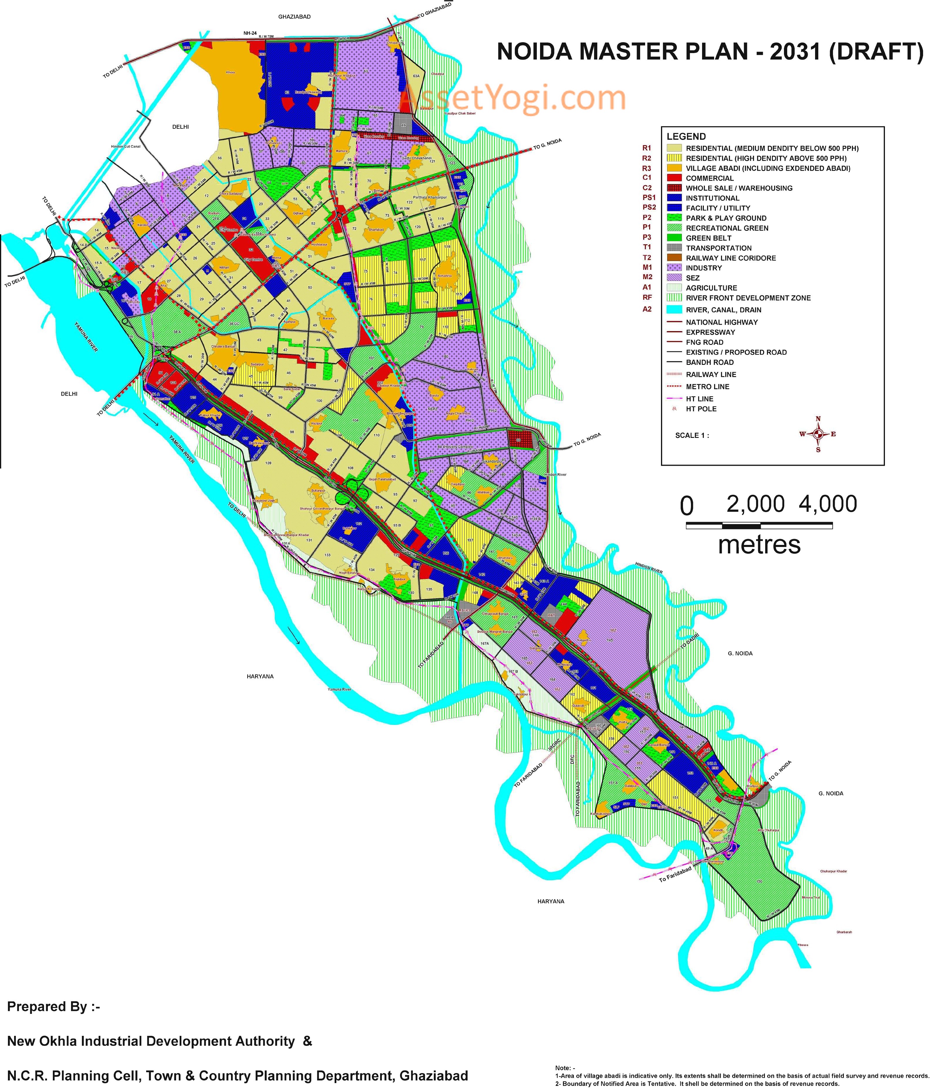
Master Plan 2031 – Map
-
Master Plan 2031 – Full Report
-
Noida-Greater Noida Metro (Route Map)
-
Master Plan 2021 – Map
Summary – Noida Master Plan 2031
Introduction
Noida, short for the New Okhla Industrial Development Authority, is a city in India under the management of the New Okhla Industrial Development Authority (also called NOIDA). It is part of National Capital Region of India. Noida is located in Gautam Buddh Nagar district of Uttar Pradesh state. The district’s administrative headquarters are in the nearby town of Greater Noida.
Noida has emerged as a major economic hub in the past couple of decades. Many International and Domestic companies from various sectors have set up their businesses and offices in Noida that include IT & ITES companies, Energy and Power Utility companies, Auto & Ancillary units, Electronics Goods manufacturers etc.
Noida also houses Film City which has emerged as a hub for major News Channels and Studios due to Noida’s proximity to Delhi, the political capital of India. Development in industry, commerce and trade have led Noida to be a model city in UP. It is a major revenue earner for the government through taxes.
Background
Noida
The history of development of the present day Noida town can be traced back to 1972 when the Government of Uttar Pradesh, taking note of the mounting pressure of speculative land dealings in this area, closely situated to Delhi and having backward characteristics of development, declared 50 villages of the erstwhile district of Bulendshahar as the “Yamuna-Hindon-Delhi Border Regulated area” under the provisions of U.P. Regulation of Building Operations Act, 1958.
There was no urban centre in this area. The Interim General Plan for Greater Delhi was prepared in 1956 and then the first Master Plan of Delhi prepared in 1962 suggested that serious considerations should be given for the planned decentralisation of large scale economic activities from Delhi and the development of towns around Delhi.
In 1988, a statutory plan for the National Capital Region of Delhi (of which Noida is a part) was finalised and enforced in for perspective year 2001. Also, a Perspective Plan for Delhi – 2001 was finalised by the Delhi Development Authority and enforced since 1990 for the perspective year 2001.
Both these Plans had significant implications for the development potential of Noida. Within the framework of the NCR Plan, Noida was given the status of a Delhi Metropolitan Area (DMA) town with an assigned population of 5.50 lakhs by the year 2001. NCR Planning Board revised the Regional Plan in 2005 for the perspective year of 2021.
The Regional Plan for the NCR – 2021 has assigned the population of 12 lakhs for Noida and accorded it a status of Central NCR town.
Greater Noida
Another factor, which is likely to have far reaching implications for the growth potential of Noida is the development of Greater Noida and Yamuna Expressway Industrial area townships on a contiguous territory east of the river Hindon.
The Government of Uttar Pradesh, with a view to curb haphazard developmental activities in this potential area, decided to acquire about 70,000 hectares of land for planned urban development. For this purpose, the State Government created the Greater Noida Industrial Development Authority (GNIDA).
UP government later got a master plan prepared for the development of a new city, namely, Greater Noida for a population of 300,000 to be achieved by the year 2001. Greater Noida is also now planned for a population of 12 lakhs by 2021. This city is also bound to expand in size with time, and being located in close proximity to Noida, would surely influence the development of the city.
LAND UTILISATION
The area has two distinct types of land utilization pattern. These are:
Urban Area
The planned integrated industrial township of Noida wherein the major industrial sectors were developed in three phases; namely, Industrial Area Phase I, Industrial Area Phase II, and Industrial Area Phase III. The residential, commercial, recreational, institutional and other urban use areas have also been developed in large parts of the township in the form of sectors.
The remaining area of the township is in the process of being developed. Three well maintained green/recreational areas have been developed, one as a recreational area along the river Yamuna, located opposite Sectors 14A, 15A and 16A, another as city level green area in Sector 54, and the third as a golf ground located in Sector 38. Other than the above, two more large recreational/ green areas are to be developed in sector 38A, one opposite Sectors 28, 29, 37 and 44; and the other as sports complex in Sector 21A and in sectors 79, 101, 104 and 150.
Rural Area
The agricultural fields exist in an interspersed manner with rural settlements in some parts of Southern area of the town. Agriculture is well developed as the soil is fertile and irrigation facilities are well provided in the area. Plantation has also been done in some pockets.
One such relatively large pocket exists at a location immediately north of the Sultanpur village and a smaller pocket exists west of the Shahdara village and located along the western bank of Noida Drain.
LAND USE AND DEVELOPMENT IN NOIDA TOWN
Land use planning for a town is a process through which attempts are made to make use of land in the best possible way for development of town. Its future size, pattern and direction of growth, form, etc., are determined through the process of land use planning, which provides a definite guideline and roadmap for the future development of the planned area.
EXISTING LAND USE DEVELOPMENT
Noida is a fast growing town. Its development during last one decade indicates that the pace of development is more than what was expected in earlier Master Plans. A detail analysis of land development based on the latest satellite images indicates that total land of approximately 9211 hectares have been developed in different land uses by January 2010 and approximately 1000 hectares land was in the process of development.
It indicates that the development of Noida has been more than what was provisionally envisaged in Noida Master Plan 2011. The Noida Master Plan 2011 was revised in 2006 for the perspective year of 2021. A total of 14964 hectare land was proposed for the development of urban activities.
A comparative analysis of land use development with reference to proposed land use in Noida Master Plan 2021 reveals that about 61.61% of total proposed land has already been developed.
Proposed Land Use (2021) vs Existing Land Use (2010)
Details of proposed land use in Noida Master Plan – 2021 and Actual development in the year – 2010
| S. | Land Use | Proposed Area for | Actual Development | % of planned | ||||
| No. | 2021 | (%) | by 2010 (%) | area of 2021 | ||||
| 1 | Residential | 5334 | 35.65 | 3357.64 | 36.45 | 62.95 | ||
| 2 | Commercial | 564 | 3.77 | 101.89 | 1.11 | 18.06 | ||
| 3 | Industrial | 3001 | 20.05 | 1267.14 | 13.76 | 42.22 | ||
| 4 | Institutional | / | 1219 | 8.15 | 813.28 | 8.83 | 66.72 | |
| Facilities | ||||||||
| 5 | Transportation | 2211 | 14.78 | 1804.31 | 19.59 | 81.61 | ||
| 6 | Recreational | 1513 | 10.11 | 1761.98 | 19.13 | 116.45 | ||
| 7 | Agriculture | 1001 | 6.69 | — | – | – | ||
| 8 | Water body | 121 | 0.81 | 104.50 | 1.13 | 86.36 | ||
| Total | 14964 | 100.00 | 9210.74 | 100.00 | 61.61 | |||
PROPOSED LAND USE PLAN
Noida has been planned on a gridiron pattern. The major roads have been planned horizontally from southwest to northeast interconnected by perpendicular roads forming a grid and dividing the area into sectors. The township is planned on the concept of self-contained integrated township.
The high-density residential areas are located close to work places. The commercial centres are well distributed over space with the main commercial hub in the city centre. The sub district centres are distributed with respect to residential catchment areas. Residential sectors are to be developed at varying densities.
Few sectors have been planned for high density Group Housing with provision of large size recreational / green areas. The central park and major public and semi public uses are located so as to run linearly in a north-south direction more or less centrally through Noida. A railway station complex is proposed in the south-western part of Noida in the Noida master plan 2031 .
POPULATION PROJECTIONS
Noida is one of the fastest growing urban centres in India. It has experienced unprecedented population growth since its establishment. Its growth during last two decades also indicates that population projections cannot be made by any normal mathematical method. The earlier drafts of Noida Master Plan had projected the population of Noida for the years of 2011 and 2021 by various methods and stipulated the population to be 7 lakhs to 9 lakhs by 2011.
Noida Master Plan 2021 adopted 12 lakhs population for 2021 on the basis of NCR Regional Plan 2021. However, primary census enumeration of 2010 reveals that Noida’s population has already crossed over to 10 lakhs in 2010. There is no relevance in having planned population of 12 lakhs for the year of 2021 when it is already more than 10 lakhs in 2010.
Hence, population projection for the purpose of planning has been adopted on the basis of commitment of land for residential purposes. It is envisaged that the physical development of entire Noida may be completed by 2021 and almost the entire residential area would have been inhabited by the year 2031.
The population figures based on the commitments of residential properties in the planned area and potential population growth in the rural settlements, as expected as per noida master plan 2031, are shown in the following table :-
Population Estimate – 2031
| S.No. | Items | Unit No./ Area | Persons per unit | No. of persons |
| 1 | No. of flats constructed by NOIDA | 34507 | 4.5 persons per unit | 155281 |
| 2 | No. of plots developed by NOIDA | 24587 | 13.5 persons per plot | 331924 |
| 3 | No. of plots for farmers | 3500 | 13.5 persons per plot | 47250 |
| 4 | Group Housing Area allotted before Dec., 08 | 628.68 Ha | 700 PPH | 440076 |
| 5 | Group Housing Area alloted after Dec 08 | 396.77 Ha | 1650 PPH | 654671 |
| 6 | Land transfer to YEA | 500 Ha | As per approved layout plan | 220500 |
| 7 | SEZ Area (1000 Ha) | 100 Ha | 1650 PPH | 165000 |
| 8 | Village Abadi | 1231 Ha | 400 PPH | 492400 |
| TOTAL POPULATION | 2507102 |
The population of Noida is estimated on the basis of above table is 25 lakhs for the year of 2031.
POPULATION DENSITY
Population of Noida is estimated to be about 25 lakhs by 2031. This may be the optimum population Noida may accommodate. In the view of city’s geographical and environmental conditions it would not be feasible to have very high concentration of population in Noida. It is therefore, proposed to have population density in the already majority developed Residential sectors below 500 persons per hectare.
Noida has planned few newly developing sectors exclusively for group housing with high density of population and high rise building. In these sectors, about 400 hectares land is allotted for group housing schemes with a density of population at the plot / scheme level as high as 1650 persons per hectare. This was a conscious decision of the Noida Authority to make the best possible and viable use of remaining residential land and to meet the increased demand for affordable housing in the NCR.
Sectors are proposed to be divided in the following two categories of population density:
- Above 500 persons per hectare – Sectors 75, 74, 117, 118, 76, 77, 116, 115, 113, 112, 78, 107, 45, 168, 93B, 86, 143, 144, 151, 162, 158.
- Below 500 persons per hectare – All other residential sectors.
The overall population density of the urban area is proposed to be 164 persons per hectare in noida master plan 2031, which is well within the 150-200 pph category suggested for Metro cities in the NCR – Regional Plan – 2021 and is also comparable with other towns.
LAND USE DISTRIBUTION
The Noida Authority is in the process of acquiring the entire land for its planned development. The total land notified for Noida is about 20316 hectares, out of which quite a large part of about 25% is in the area beyond embankments of river Yamuna and Hindon.
This is flood prone area and suitable to river front development only. This area is not suitable for urbanization. Hence, about 15280 hectare land situated broadly between the two river embankments is proposed for planned urban development.
Industrial Activities are dominant economic functions of Noida. Since its infancy, Noida has been envisaged predominantly an Industrial township. It has necessitated to the reservation of more land for Industrial uses. The Noida Master Plan -2021 had proposed about 20% percent land for Industrial use. With slight modification about 18.37 percent land is proposed under Industrial uses for 2031.
A comparative analysis of land use distribution in Noida Master Plan – 2021 and in proposed Noida Master Plan 2031 has been shown in the following table.
Proposed Landuse
Landuse distribution as Proposed in Noida Master Plan-2021 and Noida Master Plan 2031
| S. | Land Use | Proposed for 2031 | As Approved for 2021 | |||
| No. | Category | Area in | % | Area in | % | |
| Ha. | Ha. | |||||
| 1 | Residential | 5722.14 | 37.45 | 5334.00 | 35.65 | |
| 2 | Commercial | 581.33 | 3.80 | 564.00 | 3.77 | |
| 3 | Industrial | 2806.52 | 18.37 | 3001.00 | 20.05 | |
| 4 | Public & Semi- | 1357.97 | 8.89 | 1219.00 | 8.15 | |
| public Facilities | ||||||
| 5 | Transportation | 1942.15 | 12.71 | 2211.00 | 14.78 | |
| 6 | Recreational | 2432.82 | 15.92 | 1513.00 | 10.12 | |
| 7 | Agriculture | 332.47 | 2.18 | 1017.50 | 6.80 | |
| 8 | Water Body | 104.50 | 0.68 | 104.50 | 0.69 | |
| Total | 15279.90 | 100.00 | 14964.00 | 100.00 | ||
DEVELOPMENT OF TRANSPORT RELATED AREAS
Regional rail and road networks have been proposed keeping in view the potentially advantageous location of Noida in relation to major transport routes linking Delhi Urban Area and Ghaziabad.
Proposed Regional Rail Linkages
A railway line has been proposed in the multi-modal transport system. This railway line will link the city of Noida with Dadri in the East and Tughlakabad of Delhi in the southwest. Railway station site and railway yard sites have been proposed near village Chaprauli. The railway station, including its appurtenances, should be planned and developed as a modern station, designed with care and sensitivity, to uphold the image of the city.
The proposed Mumbai-Delhi dedicated Rail freight corridor will pass through Noida. Accordingly, in the noida master plan 2031, a Rail corridor has been proposed for this in sector 160 and 146. A railway station and a Rail freight yard and logistic park are proposed in sector -160 to cater to the demand of freight’s transit in Noida.
Metro Corridor
At present, Metro Line Service is operational between Delhi and City Centre of Noida. There are Metro Stations in Sector -15, 16, 18, 38A, 38 and 32. Noida and Greater Noida Authority have proposed the extension of Metro Service from City Centre Noida to Bodaki Railway Station in Greater Noida through Pari-Chowk.
This corridor will have 14 new stations in Noida. DMRC has carried out a detailed survey for this Metro Corridor and has prepared a Detailed Project Report. DMRC and Noida Authority are proposing some other linkages of Metro service to be developed in the third phase.
There are two such potential linkages-Botanical Garden to Sarita Vihar through Kalindi Kunj in Delhi and the other from City Centre to NH-24 and City Centre to Greater Noida through sector -121. These Metro corridors will be accessible at selected intervals through stations as per noida master plan 2031. The intra city transport system will be integrated with the Metro corridor through the stations and feeder bus services on intra city road network.
Proposed Regional Road Linkages
The proposed road linkages will connect the city with the regional movement system to and from the city. There are two major roads that have been proposed in Noida, one is the Expressway linking Noida with Greater Noida and another road in the multi-modal corridor that will connect the city with Ghaziabad in the north and Faridabad in the south.
A new road link between Noida and Faridabad is proposed connecting the N.H -2 with Noida – Greater Noida Expressway near sector 150 and 152 of Noida in Noida Master Plan 2031. This proposed road link will help in connecting the National highway No. 2 with Noida, Greater Noida, National highway No. 91 and further with National highway No. 24 near Hapur through a proposed 120 mts wide road in Greater Noida phase II.
MIXED LAND USE
The Noida Authority has introduced the policy of mixed land use in the Noida Master Plan 2021 when residential and other activities were permitted in the planned commercial land along the major roads. The retail commercial activities were allowed to be restricted on the ground floor and residential activities were allowed on the upper floors. The concept of mixed land use is becoming popular in all the cities.
Residential facilities are allowed in commercial and institutional area to make the better utilization of land for varying uses and also to contain the requirement of transport facilities for work places. Noida Authority also decided to allow the mix of commercial, residential and institutional activities on the designated large size residential or institutional plots available in different sectors.
The ground coverage and floor area ratio shall be in accordance of the prime land uses of the plot. The Authority may decide the architectural controls, procedure of allotment, reserve prices and other requirements as per the proposed mix of activities on a plot or scheme.
Specific areas of mixed land use have not been proposed in the Noida Master Plan 2031. However, the Authority may identify such land or plot for mixed land use schemes at the time of detail layout plan of a particular sector or area.
Ref: Noida Authority