Sohna Master Plan 2031 has been prepared to provide vision & regulations for development and building activity in the city of Sohna in Haryana. It envisages a population of 6.4 lakhs by 2031 in Sohna. Accordingly 5600 hectares of land is earmarked as urbanisable area under the proposed land use by 2031 in Sohna master plan.
You can download the official Master Plan 2031 map for Sohna and the government notification from here. Check out the summary of Sohna Master Plan 2031 below. You can share your opinions or suggestions in the comments section at the end.
Downloads
-
Official Master Plan 2031 – Map (B&W)
-
Master Plan 2031 – Reference Map (Color)
-
Notification – Master Plan 2031
Summary – Sohna Master Plan 2031
Introduction
About Sohna
Sohna is an important old town in the backdrop of picturesque Aravalli Ranges on its West. The town derived its name from the gold dust which was found in the sand of streams, after heavy rains in the beds of the neighboring torrents. The City of Sohna is a popular tourist location, especially as a weekend and conference retreat.
It is famous for its hot springs and ancient Shiva temple. Because of their faith and belief, people having skin diseases visit this town to have a holy and clinical dip in the Kunds having spring water to get rid of their diseases.
Provision and maintenance of civic amenites in the town are being done by Municipal Committee. It is a tehsil of Gurgaon District. The town provides shopping, educational, medical and mandi facilities to the surrounding rural areas.
Sohna is located 24 km from the city on the highway from Gurgaon to Alwar, near a vertical rock and is an important junction at Palwal-Sohna-Rewari (N.H.-71) road. Other important cities/towns in the region around Sohna are Delhi (56 km.), Gurgaon (24 km.), Faridabad (35 km), Palwal (30 km), Nuh (20 km) and Rewari (45 km).
Infrastructure
The town is very well served by frequent bus services from all sides. The Kundli-Manesar-Palwal (KMP) Expressway which is under construction is passing by the southern side of the town. This is a major artery in western side of Delhi in the NCR portion of Haryana connecting Kundli to Palwal via Manesar. Two clover- leaf junctions are being developed on the KMP Expressway that will enhance accessibility of this region substantially.
A 50 m wide strip of land has been reserved for Orbital Rail Corridor along KMP Expressway towards Delhi side. The Dedicated Freight Corridor (DFC) linking Delhi to Mumbai, is also passing by the south- eastern side of the town. The land for DFC has already been acquired. Thus, the Sohna Town has high potential for development.
In view of developing Sohna into a planned city, Final Development Plan of Sohna 2031 AD (Sohna Master Plan 2031) was notified on 15 Nov 2012.
Population
Population Projection of Sohna Town:
| Year | Number of Persons | Growth Rate (percentage) | |
| 1941 | 5750 | — | |
| 1951 | 5138 | (-) 10.64 | |
| 1961 | 6887 | (+) 34.04 | |
| 1971 | 8775 | (+) 27.41 | |
| 1981 | 12688 | (+) 44.59 | |
| 1991 | 16348 | (+) 28.85 | |
| 2001 | 38115 | (+) 133.15 | |
| *2011 | 67785 * | (+) 77.85 | |
| 2016 | 119301 | (+) 76.00 Induced Growth | |
| 2021 | 208777 | (+) 75.00 –do– | |
| 2026 | 365361 | (+) 75.00 | –do– |
| 2031 | 639382 | (+) 70.00 | –do — |
| Say = 6,40,000 | |||
* Includes 31348 (population of urban villages)
The population of Sohna town in 2011 AD including the population of villages falling in urbanisable limit is 67,785 persons approximately and in 2021 AD, the projected population is estimated to be 2,08,777 persons. Further, it is envisaged that upto 2031 A.D. the population would be 6,40,000 persons as per Sohna Master Plan 2031.
This exorbitant growth rate is expected to be induced by the following factors:
- Kundli- Manesar-Palwal (KMP) Expressway passing by the southern side of Sohna Town.
- Dedicated Freight Corridor (DFC) passing by the south-eastern side of Sohna Town.
- Haryana State Industrial & Infrastructure Development Corporation (HSIIDC) has already acquired approximately 600 hectares land for development of an Industrial Model Township (IMT) between Sohna Town and KMP Expressway.
- HSIIDC is further planning development of additional 600 hectares (approximately) for expansion of IMT.
- Haryana Government has envisaged development of theme hubs namely Leisure Hub, Sports Hub and Leather Hub along KMP Expressway in proximity of Sohna Town.
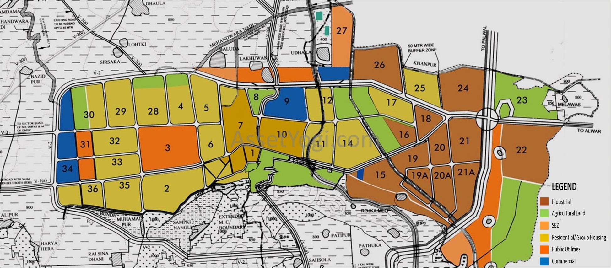
Proposed Land Use
Location & Topography
Due to topographical conditions of the area around Sohna, the suitable land for the urban development lies in the north-east, east and south-east of existing Sohna town. The main Sohna town is surrounded by Aravalli ranges from three sides.
In the north-west side, three bundhs are existing that protect the town from the run-off coming in the rainy season from western and north-western Aravalli ranges. This run-off and run-off coming from north-eastern Aravalli ranges flows through Nallah, namely Mehandwara Nadi upto Indri lake. In the south-west side of the town, there is forest land and low lying flood prone area.
Sohna Town is surrounded by Aravalli Ranges on eastern & western side. In the rainy season, run-off from these ranges passes through proposed urbanization through barsati Nallahs namely Mehandwara Nadi. Three bundhs namely Sohna bundh, Mohmmadpur bundh and Ghamroj bundh exist on the western side of the town to check the run-off and for recharging the underground water table.
All the three existing bundhs and alignment of the tributaries of Mehandwara Nadi / Nallah have been retained as such in the Sohna Master Plan 2031 on the request of the Irrigation Department. It is pertinent to mention here that the three tributaries of Mehandwara / Nallah that passes through the proposed urbanisable area cross sector dividing roads at many places and a number of bridges / culverts will have to be constructed, wherever these are required.
However, while implementing the development plan proposals, the possibility to realign these water channels shall also be explored.
Land Use Plan
The Sohna Master Plan 2031 comprises of 45 controlled areas measuring 45,687 hectares. It has been prepared for a population of 6,40,000 persons. The existing population of Sohna Town and villages falling under proposed urbanization is 67,785 persons i.e. 174 persons per hectare (PPH) or 70 PPA.
It is expected that due to induced rapid and planned urban development the spill-over effect will take place and existing population of Sohna Town and urban villages will be reduced. The additional 1719 hectares residential area proposed in the development plan would cater to the residential demand of 5.72 lakhs person.
The proposed gross density of Sohna Town is 90 PPH and for optimum utilization of land as resource, the density proposed for new residential area is 300 PPH. The extent of various land uses in the Sohna Master Plan 2031 are as under:-
| Sr. No. | Land Use | Area in hectare | Percentage |
| 1 | Residential | 1719 | 30.70 |
| 2 | Commercial | 255 | 4.55 |
| 3 | Industrial | 1236 | 22.07 |
| 4 | Transport & Communication | 627 | 11.20 |
| 5 | Public Utility | 241 | 4.30 |
| 6 | Public & Semi Public | 573 | 10.23 |
| 7 | Open space & Green belts | 949 | 16.95 |
| Total | 5600 | 100.00 | |
| 8 | Existing Town | 266 | |
| 9 | Village Abadi | 125 | |
The proposals exclude the 391 hectares of the existing abadi of urban villages & town.
Description of Land Uses
Residential
To accommodate projected population, an additional area of 1719 hectares has been proposed for the development of residential sectors. It is relevant to mention here that sector-17 & 25 have been proposed adjoining the industrial sectors for providing housing to industrial workers.
Further two pockets i.e. one of 50 hectares in sector-25 and one of 16 hectares in sector-31 are reserved for low and medium income group with higher population density of 1125 persons per hectare (PPH). The proposed average residential density is 300 persons per hectare.
The residential areas proposed in the Sohna master plan 2031 shall be developed on neighbourhood concept by making provision of all the community facilities and services within the sectors. Keeping in view the scarcity of water in district Gurgaon, endeavour shall be made to develop all the sectors / colonies on zero discharge concept for encouraging the use of recycled water.
The following proposals are made to absorb the impact of increased residential density:-
- Additional area for infrastructure shall be provided in the already planned / developed residential sectors to meet out the requirement of the additional population.
- Minimum width of the roads in a residential colony/ sector shall not be less than 12 meters.
- Minimum area for parks / open spaces in a residential colony / sector shall be planned in such a manner that it shall meet the minimum norm of 2.5 square meters per persons.
- A strip of 120 m width approximately has been provided around the village abadies falling within the urbanizable limit of the town for the purposes of village expansion / for providing amenities to the villages.
Commercial
The main commercial business is being done in the narrow streets/bazars of the existing town. The potential area for the commercial activity is along eastern peripheral road. Accordingly, total area of 255 hectares has been proposed for commercial use mainly along this peripheral road.
A commercial pocket existing in industrial sector 15 was planned by Haryana Urban Development Authority to cater to the commercial need of the industrial sectors. Under sohna master plan 2031, a commercial pocket of approximately 37 hectares for Mandi (vegetable, fruits, grains etc) and also for heavy building material is proposed in sector-27 along eastern bye pass.
Industrial
The industrial area Rozka Meo and Textile Valley (sector 15) developed by Haryana Urban Development Authority covering an area of approximately 89 Hectares is falling on Sohna-Nuh Road. The demand of industrial developed plots / land in this area is increasing day by day due to KMP Expressway and Dedicated Freight Corridor.
In order to cope up with this demand and future demand, total area of approximately 1236 hectares has been proposed for industrial use on southern side of the town along KMP Expressway. The land located in these sectors is mainly waste land, not being used for agricultural purpose.
HSIIDC has already acquired 607 hectares land along KMP Expressway for developing IMT. This land is low- lying as per report of Irrigation Department Haryana as well as HSIIDC and is flood prone. Hence, HSIIDC needs to take special measures while developing this low-lying area for urbanization including the area demanded by it for future expansion.
Transport and Communication
An area of approximately 627 hectares has been proposed for Transport & Communication Zone in Sohna master plan 2031. An area measuring 99 hectares in sector- 27 has been proposed for Transport Nagar along Dedicated Freight Corridor (DFC). The eastern & western peripheral roads of 75 m width have been proposed with 100 m wide green belt on outer side and 50 m green belt on inner side. A minimum width of 60 meters has been proposed for sector dividing roads.
The width of Gurgaon-Sohna-Alwar road, Rewari- Sohna-Palwal (NH-71) road and Sohna-Ballabgarh Road has been proposed to be widened to 60 m with 50 m wide green belt on either sides. The roads proposed through Aravalli Hills shall be constructed after obtaining permission of the Competent Authority. An area of approximately 12 hectares has been proposed in Sector-3 for new bus stand.
Classification of Roads
The classification of roads and land reservation in sohna master plan 2031 has been given in following table:-
| Serial | Classification | Land reservation | |||||
| number | |||||||
| (i) | Kundli-Manesar- | 100 m wide road with 100 m wide green belt on both sides | |||||
| Palwal Expressway | |||||||
| (ii) | Orbital | Rail | 50 m wide. | ||||
| Corridor | |||||||
| (iii) | V-1 road | Arterial | Existing Gurgaon-Sohna-Alwar Road and Sohna-Palwal Road within Old M.C. | ||||
| roads | Limit. | ||||||
| (iv) | V-1(a) road | Existing Road to be widened to 60 m with 50 m wide green belt on both sides. | |||||
| (v) | V-1(b) road | 60 m wide road with 50 m wide green belt on either sides. | |||||
| (vi) | V-2 road | 75 m wide road with 100 m wide green belt on outer side and 50 m wide green | |||||
| belt on inner side. | |||||||
| (vii) | V-3 road | Sub | 60 m wide road. | ||||
| (viii) | V-3(a) | Existing Road to be widened to 45 m. | |||||
| arterial | |||||||
| (ix) | V-3(b) | 45 m wide road. | |||||
| roads | |||||||
| (x) | V-4 road | 30 m wide road. | |||||
The width and alignment of other roads shall be as per sector plans or as per approved layout plans of colonies. Wherever road shown in the Master Plan are found to be non-feasible, as per ground condition, Government shall be competent to realign/delete the same after recording the reasons thereof. In addition to above, HSIIDC shall reserve an area measuring 4 hectares in each industrial sector to be developed for parking.
The proposed western peripheral road (V-2) shall be constructed by taking special measures in order to avoid obstruction in the flow of run-off coming from western and north- western Aravalli Ranges, reaching to the proposed “Water Recharge Zone” and further to Indri lake via Mehandwara Nadi and its tributaries.
Public Utilities
An area of about 241 hectares has been earmarked in sohna master plan 2031 for public utilities to meet out future needs of the town. Considering ground conditions, provisions have been made for water works sites, grid sub-station sites, solid waste site (on southern side of KMP along Nuh Sub-branch) & sewage treatment plant site (near village Kherki Kankar). Feasibility of laying underground electricity lines upto 66 KV shall be examined.
Public and Semi-Public
In order to cater to the future demand, an area of approximately 573 hectares has been proposed for public and semi public uses. Sector- 3 is proposed as full-fledged sector for public and semi public; uses. Besides, small pockets have also been proposed along peripheral as well as along southern side of KMP for proper spatial distribution.
Provision of a college each in sectors 1, 2, 3, 14 & 17 has been made. A Medical College with Hospital over an area of 14 hectares in sector-3, a 100 bedded hospital over an area of 4 hectares in sector-1 and a 50 bedded hospital over an area of 2 hectares in sector 17 have been provided.
In sector -1, provision of a fire station has been made. A college, a fire station and an auditorium have been proposed in public and semi public belt along eastern peripheral road opposite sector-7.
Open Spaces
With the development of a beautiful tourist recreational complex at Sohna, it has started attracting tourists and people from the surrounding regions for picnic and funfair. With its scenic beauty all around, Sohna has a potential to be developed as a regional recreational center also.
An area approximately 315 hectares has been proposed for parks etc. A 100 meter wide green belt on outer side and 50 m wide green belt on inner side of peripheral road, 50 m wide green belt on both sides of Taoru-Sohna-Palwal (NH-71) road, Gurgaon-Sohna-Alwar Road and Sohna-Ballabgarh Road, a 30 m wide green belt on both sides of Dedicate Freight Corridor (DFC) and Nuh sub-branch passing through urbanization have been proposed.
in Sohna Master Plan 2031, the total area under these green belts is approximately 484 hectares. An area approximately 150 hectares has been proposed for Sports Complex in sector-23 along KMP Expressway. Total area proposed under Sports Complex / Open Spaces / Parks / Green Belts is about 949 hectares.
An area measuring 4 hectares has been proposed for the burial ground on the north-west side of the town near village Haryahera along revenue rasta leading to village Raisina from Gurgaon Sohna Road.
Agriculture Zone
A sizeable area of about 34793 hectares has been reserved as agricultural zone, which includes forest land, Village abadies and existing structures. This zone will, however, not eliminate the essential building development within this area such as the extension of existing village contiguous to abadi-deh if undertaken under project approved or sponsored by Government or other ancillary and allied facilities necessary for maintenance and improvement of an agricultural area.
The land under forest measuring 10,553 hectares comprises of the land under Reserve Forest, under section 4 and/or 5 of Punjab Land Preservation Act (PLPA), 1900, under Aravalli Plantation, Unclassified Forest and forest coming under section 38 of Indian Forest Act, 1927. The details of forest area have been incorporated in the plan as per information provided by Forest Department.
Since the Forest Department is in the process of preparation of a Geo-referenced Forest Map for District, Gurgaon, therefore, the areas identified by the Forest Department as “forest” apart from the areas intimated by the Forest Department, shall be deemed to have been incorporated in the Sohna Master Plan 2031. Further, the Wildlife Corridor, if any, within the proposed Agriculture Zone, shall also be followed.
It is pertinent to mention that though the area notified under section 4 and/or 5 of PLPA and areas under Aravalli Plantation are not forest per se, but the same have been considered as forest in terms of the orders Supreme Court of India till the same are modified.
The provision of Gaushala/ Cattle Pond over an area approximately 5 hectares has been made on Sohna-Palwal road near village Sancholi.
Water Recharge Zone
An area measuring approximately 340 hectares has been reserved as “Water Recharge Zone” to check the run-off that will replenish the depleting underground water table. No permission for any type of construction will be granted in this area. In order to keep this area free from unauthorized constructions, the possibility of acquiring the land under water recharge zone shall be explored by HUDA/ Irrigation Department.
Natural Conservation Zone
The Aravalli Ranges have been designated as Natural Conservation Zone in master plan of sohna 2031. The total area under this zone is 4563 hectares. Agriculture, horticulture, pisiculture, social forestry, afforestation and regional recreational activities with construction not exceeding 0.5% of the area are the permissible activities in this zone, excluding forest areas.
Environmental Concerns
For protection of Aravallis, the notification of the MoEF, Government of India dated 07.05.1992, shall be applicable. Similarly, for execution of any project, the project proponent will have to obtain environmental clearance in terms of notification dated 14.09.2006, which is mandatory in nature.
In addition, the areas notified under Section 4 and/or 5 of Punjab Land Preservation Act, 1900 and areas covered under Aravalli plantation are also shown as “forest”, in view of the orders of the Hon‟ble Supreme Court, in which no urbanization shall be allowed. Similarly, the restrictions applicable to eco-sensitive zones or for protection of environment in any manner shall also be followed and implemented.
Further, pumping of ground water in and from an area upto 5 kilometers from Delhi Haryana Border in the Haryana side of the ridge and also in the Aravalli hills shall be prohibited in accordance with the orders of the Hon‟ble Supreme Court. Notifications issued by MOEF, Government of India, from time to time shall be applicable and binding.
Conservation of Heritage Sites
The monuments, heritage sites, special areas of aesthetic, sentimental or historic value which require protection shall be protected.
Area Statement
The total area of the Sohna Master Plan 2031 comprising of 45 controlled areas is about 45687 hectares. The break-up of the area under various zones is as follows:-
| S.No. | Particular | Area (hectares) |
| i) | Urbanisable Area | 5600 |
| ii) | Agriculture Zone (including forest land, Village abadies and existing structures | 34793 |
| iii) | Water Recharge Zone | 340 |
| iv) | Natural Conservation Zone | 4563 |
| v) | Area under existing town and abadi (inside proposed urbanization) | 391 |
| Grand Total | 45687 |