Gurgaon Master Plan 2031 is the latest master plan that is released by Town and Country Planning Department of Haryana.
Master Plan 2021 for Gurgaon was released on 5th Feb 2007 for a population of 37 lakhs and with a population density of 80 ppa (persons per acre).
However, owing to fast urbanisation, Gurgaon Master Plan was revised for 2025 with a population density 120 ppa. In Gurgaon Master Plan 2025, a large area was earmarked for setting up of SEZs. However, demand for SEZs decreased and the whole industry scenario changed. So, development plan of 2025 was further revised to Gurgaon Master Plan 2031 (latest master plan) to change the proposed land use of earlier notified SEZ land.
Ultimately, Gurgaon-Manesar Urban Complex – 2031 AD final development plan (Gurgaon Master Plan 2031) was published on 15 Nov 2012 to cater to a population of 42.5 lacs.
You can download all Gurgaon Master Plans of 2031, 2025 and 2020 from here. Check out the summary of latest Gurgaon Master Plan 2031 below. You can share your opinions or suggestions in the comments section at the end.
DOWNLOADS
Gurgaon Master Plan 2031
-
Official Master Plan 2031 – Map (B&W)
-
Unofficial Master Plan 2031 – Reference Map (Color)
-
Notification – Gurgaon-Manesar Urban Complex 2031 Final Development Plan
Gurgaon Master Plan 2025
Gurgaon Master Plan 2021
Highlights – Gurgaon Master Plan 2031
Introduction
The Gurgaon-Manesar Urban Complex, which is known for Automobile Industries, Modern Commercial Malls, Towers of Cyber Parks and Software Development, is situated on prime location on National Highway Number 8, only at a distance of 4 kilometres from the Indira Gandhi International Airport and is well linked with all capitals of the world through airways.
Gurgaon has emerged as a new International city. Many multinational companies have set up their corporate offices, software development centers, manufacturing units and other businesse in Gurgaon and Manesar.
The availability of high level infrastructure of Airways, Railways, Highways, world famed medical and educational institutions in its close proximity at National Capital of Delhi have become the main factors of attraction for international companies for setting up their business at Gurgaon.
In order to meet the demands of foreign investors and also to set up hi-tech non-polluting industrial units, the Haryana Government initially with the collaboration of Japanese entrepreneurs started setting up Industrial Model Township at Manesar in 1992 through Haryana State Industrial and Infrastructure Development Corporation. The said Corporation has developed about 700 hectares land at Manesar and now the developed land is being made available to all entrepreneurs of the world including India.
Public and Private Development
The Haryana Urban Development Authority in public sector and licensed colonizers in private sector through Town and Country Planning Department have also played prime role in achieving planned development in Gurgaon – Manesar Urban Complex.
The Haryana Urban Development Authority and the licensed colonizers collectively have developed about 8000 hectares land for residential, commercial, institutional and industrial purposes to meet the increasing demand of the public.
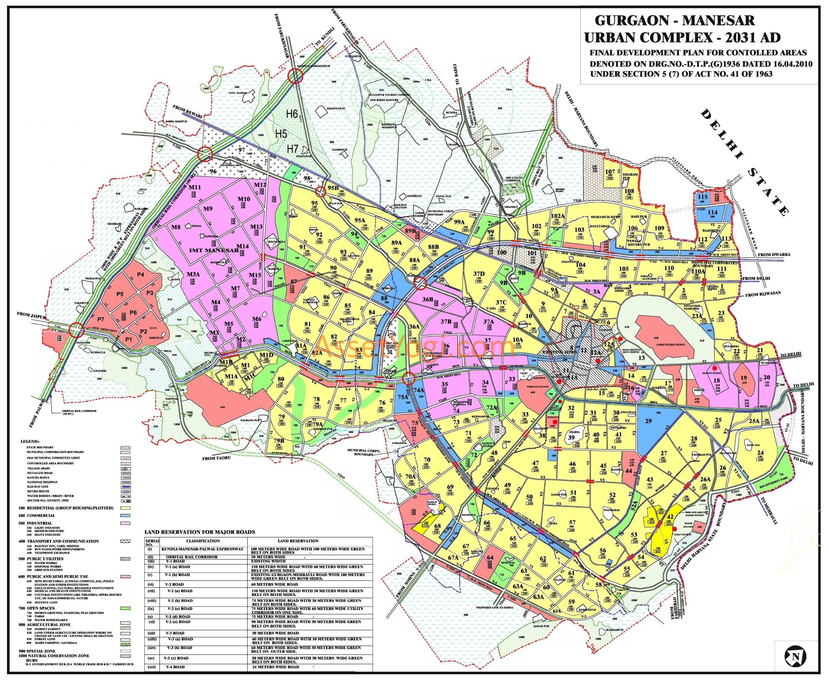
The areas of Gurgaon-Manesar Urban Complex which have so far been developed in public and private sector including existing town and village abadies would accommodate 22 lacs population. In order to cater to the future demand of Gurgaon-Manesar Urban Complex an additional area of 22957 hectares has been added in the form of urbanisable area for the said complex to accommodate 20.50 lacs additional population.
Thus, the total urbanisable area of Gurgaon- Manesar Urban Complex would accommodate 42.50 lacs population by 2031 AD.
Background
Gurgaon Master Plan 2021
Gurgaon Manesar Urban Complex – 2021 development plan was published on 5th February, 2007 for a projected population of 37 lacs and with a population density of 80 PPA (persons per acre). Later, it was decided to increase the sector density from 80 PPA to 100 PPA and from 100 PPA to 120 PPA in all the Development Plans of the towns/ cities in the State.
Also, it was observed that the sector roads leading from sectors-58/61, 59/60, 61/62, 60/63, 62/65, 63/64, 65/66 and sectors 64/67 were ending abruptly. Accordingly, it was proposed to improve the road network of these sectors. Besides, it was observed that a Nallah (Kost) passed through sector-58 to 66 in a haphazard manner. A technical Committee conducted a study and suggested for realigning the nallah along Southern Peripheral Road.
Gurgaon Master Plan 2025
The Development Plan was revised for the perspective year of 2025 AD after following prescribed procedure. Resultantly, there was no substantive change in the urbanizable area or land use plan except marginal increase in the urbanizable area of the Development Plan to the extent of only 1.18% (approx.).
In the Development Plans of 2021 and 2025, a large area measuring 4570 hectares was earmarked for setting up of SEZs. The scenario regarding setting up of SEZs underwent sea change since notification of these Plans and virtually there were no more takers for SEZs.
Even the already notified SEZs were not being implemented and resultantly, the landowners of such land were demanding replanning of their land so that they were able to utilize the same for some other purpose. Therefore, on a reference received from the Industries Department, the exercise to replan these areas was initiated. This was the primary reason for initiating revision of the Final Development Plan of 2025 AD.
Gurgaon Master Plan 2031
Finally, the Gurgaon-Manesar Urban Complex – 2031 AD final development plan (Gurgaon Master Plan 2031) was published on 15 Nov 2012 to cater to a population of 42.5 lacs.
Proposed land uses
The extent of various land uses as proposed in the Gurgaon Master Plan 2031 are given as below: –
| Sr. No. | Land use | Area (in Hectares) |
| 1 | Residential | 16021 |
| 2 | Commercial | 1616 |
| 3 | Industrial | 4613 |
| 4 | Transport and Communication | 4428 |
| 5 | Public Utilities | 608 |
| 6 | Public and semi public | 2027 |
| 7 | Open spaces | 2928 |
| 8 | Special zone | 114 |
| 9 | Defence land | 633 |
| Total land | 32988 | |
| 10 | Existing town | 406 |
| 11 | Village abadies | 478 |
| Grand total | 33872 |
Description of Land Uses
Residential
In order to cater to the projected population of 42.50 lacs as per Gurgaon Master PLan 2031, an area of 16021 hectares has been reserved for residential purpose. The Haryana Urban Development Authority and licensed colonizers have already developed residential area of 8000 hectares in various residential sectors of this Development Plan.
The aforesaid residential areas developed in public and private sectors would accommodate population of 20.00 lacs. The existing town and village abadies falling within the urbanisable area are also accommodating 2 lacs population. The additional residential area proposed in the Development Plan would cater to the residential demand of rest of the 20.50 lacs projected population.
The residential areas proposed in the gurgaon master plan 2031 shall be developed on neighbourhood concept by making provision of all community facilities and services within the sectors on an average net residential density of 250 persons per hectare.
Increased Density
In order to absorb the impact of increased density on the environment of the sectors, it is proposed that:-
- The additional area for infrastructure shall be provided in the already planned/developed residential sectors to meet out the requirement of the additional population.
- The minimum width of the roads in a residential colony/sector shall not be less than 12 metres.
- The minimum area for parks/open spaces in a residential colony/sector shall be planned in such a manner that it shall meet the minimum norm of 2.5 square metres per person.
In addition, so as to provide affordable housing to the public, Government is contemplating issuance of a separate policy in which not only upper sale price will be fixed but the entire allotment will also be done by the Government.
Commercial
In gurgaon master plan 2031, an area of 1616 hectares land has been reserved for commercial purpose, out of which Haryana Urban Development Authority has developed 480 hectares land. The new commercial areas proposed in the Master Development Plan of Gurgaon shall be developed in the form of big commercial malls and corporate commercial complexes.
In addition, the commercial belts with a width of 200 metres have also been provided along selected roads to cater to the needs of the surrounding areas. In order to meet out requirement of wholesale trading of building materials, grains, fruits and vegetables, approximately 48.50 hectares land has been reserved along Delhi-Rewari Railway line in sector 99A, which shall exclusively be developed by the Government or its agencies.
Industrial
The demand for developed industrial plots / land in Gurgaon-Manesar Urban Complex is increasing day by day. In order to cope-up with the demand of software industries, Automobile industries and other pollution free hi-tech industries, an area of 4613 hectares has been reserved for industrial use in gurgaon master plan 2031.
The Haryana State Industrial and Infrastructure Development Corporation and Haryana Urban Development Authority have already developed an area of 1246 hectares in the said complex. The new industrial areas have been proposed along expressway adjacent to Industrial Modern Township Manesar.
Transport and Communication
For solving the inter-city and intra-city traffic problems of Gurgaon-Manesar Urban Complex, new road links with Delhi Metropolitan City and upcoming Sohna town have been proposed in the master plan of gurgaon (2031) as mentioned below: –
-
- 90 metres wide road link between Vasant Kunj in Delhi to Mehrauli road in Gurgaon.
- 90 metres wide road link from Andheria Mor in Delhi to Gurgaon-Faridabad road in Gurgaon through Mandi and Gual Pahari.
- 150 metres wide road link between Dwarka residential complex of Delhi to Gurgaon at National Highway number 8 before Toll Plaza towards Gurgaon.
- 90 meters wide road link from junction of sector 63A/64 with V3(b) road of Gurgaon-Manesar Urban Complex-2031 AD to sector dividing road of sector 30/31 of Development Plan of Sohna -2031 AD.
In the new urbanisable area, the width of sector dividing roads have been proposed as 75 metres and 60 metres. Haryana Urban Development Authority has already developed auto market in sector 10 in an area of 16 hectares.
Transport Nagar
A Transport Nagar has also been developed by Haryana Urban Development Authority in an area of 28 hectares in sector 33. In order to cater to the future demand of the public, the Transport Nagar and Container Depots have been proposed adjoining to Garhi Harsaru Railway Station on Delhi-Rewari Railway line.
A pocket of 45 hectares of land has been reserved for idle parking adjoining village Garhi Harsaru along railway line opposite to wholesale market proposed in sector 99A.
Metro
Existing Delhi-Gurgaon Metro Link which terminated at HUDA City Center (Sector 29) is proposed to be extended upto Manesar via Sector 43-44, 52-52A, 56-57, SPR and NH-8. Another Metro loop taking off from Sikanderpur Metro Station and passing through Sector 25-25A is nearing completion. This Metro link is proposed to be extended upto SPR through Golf Course Road.
MRTS
An additional “Mass Rapid Transit System Corridor” along the 150 metres wide northern link road to Delhi extending from Dwarka in Delhi has been proposed upto Inter State Bus Terminal proposed near village Kherki Duala. The area shown under Inter State Bus Terminal is approximately 162 hectares which can be very appropriately used for Inter State Bus Terminal-cum-Mass Rapid Transit System Depot.
The alignment of Regional Rail Transit System (RRTS) linking Delhi to Alwar via Gurgaon passes along NH-8. An Integrated Mobility Plan for GMUC has already been got conducted from Urban Mass Transit Co. Ltd. (UMTC) and its recommendations have been accepted by the Government.
Various recommendations have been made by UMTC for facilitating the movement of motorized, non-motorized and pedestrian traffic. These recommendations will be implemented earnestly by the executing agencies like HUDA, HSIIDC, Municipal Corporation, Gurgaon and PWD (B&R).
Land Reservation for Transport Corridors
Land reservation for major transport corridors marked in the drawing are as under:-
| Serial | Classification | Land reservation |
| number | ||
| (i) | Kundli-Manesar-Palwal | 100 metres wide road with 100 metres wide green belt on both sides |
| Expressway | ||
| (ii) | Orbital Rail Corridor | 50 metres wide |
| (iii) | V-1 road | Existing width |
| (iv) | V-1(a) road | 150 metres wide road with 60 metres wide green belt on both sides |
| (v) | V-1(b) road | Existing Gurgaon-Mehrauli road with 100 metres wide green belt on both |
| sides. | ||
| (vi) | V-2 road | 60 metres wide road |
| (vii) | V-2 (a) road | 150 metres wide road with 30 metres wide green belt on both sides |
| (viii) | V-2 (b) road | 75 metres wide road with 30 metres wide green belt on both sides |
| (ix) | V-2(c) road | 75 metres wide road with 60 metres wide utility corridor on one side |
| (x) | V-2(d) road | 75 metres wide road |
| (xi) | V-2(e) road | 90 metres wide road with 30 metres wide green belt on both sides |
| (xii) | V-3 road | 30 metres wide road |
| (xiii) | V-3(a) road | 60 metres wide road with 50 metres wide green belt on both sides. |
| (xiv) | V-3(b) road | 60 metres wide road with 50 metres wide green belt on outer sides |
| (xv) | V-3(c) road | 30 metres wide road with 30 metres wide green belt on both sides |
| (xvi) | V-4 road | 24 metres wide road. |
The width and alignment of other roads shall be as per sector plans or as per approved layout plans of colonies. Wherever, road shown in gurgaon master plan 2031 map are found to be non-feasible, as per ground condition, Government shall be competent to realign / delete the same after recording the reasons thereof.
Public Utilities
An area of approximately 608 hectares has been proposed for public utilities in sector 37D, 99A, 100, 101 and 107 to meet out the future needs of the proposed population. Feasibility of laying underground electricity lines upto 66 KV shall be examined.
The site of Solid Waste Disposal of Gurgaon and Faridabad has been provided in the revenue estate of village Bandhwari which forms part of Development Plan of Gual Pahari. The capacity of the plant is sufficient for the present needs of the population of Faridabad and Gurgaon cities.
For additional required sites for Solid Waste Disposal, disposal of silt/debris and for carcasses are to be identified by the expert committee in accordance with the relevant norms and orders of the Hon‟ble High Court in consultation with Urban Local Bodies Department for the population projected in the instant plan. All these three sites may be identified in controlled areas forming part of this Plan or other Development Plans/Controlled Areas.
Public and Semi-Public
In order to cater to the institutional demand of 42.50 lacs population, an area of 2027 hectares has been proposed for public and semi public uses, out of which an area of 135 hectares has already been developed by Haryana Urban Development Authority.
In the proposed 200/172 metres wide institutional belt towards south of 60/90 metres outer periphery V-3(b)/V2(e) road, the Government offices and semi-Government offices will be permitted. This institutional belt shall be developed by HUDA. An area of 215 hectares of land has been reserved for University in sector 68, which shall also be exclusively set up by the Government / its Agencies.
Open Space
A 900 metres wide strip of land around the ammunition depot has to be kept free from urbanization under the provision of the Works of Defence Act, 1903 (Act 7 of 1903). Provision of green belts along Delhi-Jaipur Highway, Railway line and Badshahpur Nallah has also been made to meet any eventuality of their possible widening in future.
Large open spaces have been proposed near Village Basai, Dhanwapur, Medawas and flowing greens in other residential areas. On Mehrauli-Gurgaon Road, the land between Sector 24 and Haryana-Delhi State Boundary measuring approx. 135 Hectares has been designated as bio-diversity park.
In the open space shown in sector 72 and sector 72 A, the storage of water in the form of artificial water body shall be planned. This would help in recharging the ground water on the one hand and would also avoid flash floods. Besides, it will add to the aesthetic beauty of the area.
Special zone
Special zone shall include recreation and entertainment, commercial, group housing and institutional uses.
Agricultural zone
A sizeable area has been reserved as agricultural zone. This Zone, however, will not eliminate the essential building development within this area such as the extension of existing villages, contiguous to abadi deh, if undertaken under a project approved or sponsored by Government and other ancillary and allied facilities necessary for the maintenance and improvement of the area as an agricultural area.
An area of approximately, 50 hectares of land near village Dhankot between GWS canal and effluent channel has been provided for dairy farming and Gaushala wherein all the existing dairies in the city are proposed to be shifted in future. The details of land under Reserve Forest, under section 4 and/or 5 of Punjab Land Preservation Act (PLPA), 1900 and under Aravalli Plantation have been incorporated in the plan as per information provided by Forest Department.
Since the Forest Department is in the process of preparation of Geo-referenced Forest Map of District Gurgaon, therefore the areas notified by the Forest Department as „forest‟ apart from the areas inti deemed to have been incorporated in Development Plan. Further the Wildlife Corridor, if any, within the proposed Agriculture Zone shall also be followed.
It is pertinent to mention that though the „area notified under section 4 and/or 5 of PLPA‟ and „areas under Aravalli Plantation‟ are not forest per se but the same have been considered as forest in terms of the orders of Hon‟ble Supreme Court of India till the same are modified.
NATURAL CONSERVATION ZONE
The Aravalli Ranges have been designated as Natural Conservation Zone in the Plan in accordance with Regional Plan-2021 except those areas which are coming in the urbanisable area. Agriculture, horticulture, pisiculture, social forestry, afforestation and regional recreational activities with construction not exceeding 0.5% of the area are the permissible activities in this zone.
ENVIRONMENTAL CONCERNS
For protection of Aravallis, the notification of the MoEF, Government of India dated 07.05.1992, shall be applicable. Similarly, for execution of any project, the project proponent will have to obtain environmental clearance in terms of notification dated 14.09.2006, which is mandatory in nature.
In addition, the areas notified under Section 4 and/or 5 of Punjab Land Preservation Act, 1900 and areas covered under Aravalli plantation are also shown as „forest‟, in view of the orders of the Hon‟ble Supreme Court, in which no urbanization shall be allowed.
Similarly, restrictions applicable to the Eco-Sensitive Zone notified around Sultanpur National Park vide MoEF notification dated 29.01.2010 or for protection of environment in any manner shall also be followed and implemented.
Further, pumping of ground water in and from an area upto 5 kilometres from Delhi-Haryana Border in the Haryana side of the ridge and also in the Aravalli hills shall be prohibited in accordance with the orders Court. Environment Impact Assessment of the plan will be carried out by an expert agency. Notification issued by MOEF, Government of India from time to time shall be applicable and binding.
CONSERVATION OF HERITAGE SITES
The monuments, heritage sites, special areas of aesthetic, sentimental or historic value which require protection shall be protected.
Development of Infrastructure
Infrastructure Development shall be undertaken by the implementing agencies in a phased manner as per requirements.
Land use distribution of Hubs
The land use detailing of Hubs proposed along KMP Expressway shall be done in accordance with the Development Plan of KMP Global Corridor.