HMDA Master Plan 2031 of Hyderabad has been prepared to provide vision & regulations for development and building activity in the Hyderabad Metropolitan Region of Telangana. It envisages a population of 185 lakhs by 2031 and accordingly 5965 sqkms of land is allocated under the proposed land use by 2031 in Hyderabad Metropolitan Region.
You can download the hyderabad master plan 2031 map from here. Check out the summary of HMDA master plan 2031 below. To share your opinions and suggestions, please use the comments section at the end.
Downloads
Summary – HMDA Master Plan 2031 (Hyderabad)
Introduction
Hyderabad is the capital city of the Indian state of Telangana in South India. Currently, Hyderabad is also the capital city for Andhra Pradesh, as per the Andhra Pradesh Reorganisation Act, 2014, an arrangement that is scheduled to last for a maximum of ten years.
Hyderabad occupies 650 square kilometres (250 sq mi), along the banks of the Musi River, it has a population of about 6.8 million and a metropolitan population of about 7.75 million, making it the fourth most populous city and sixth most populous urban agglomeration in India.
Hyderabad was historically known as a pearl and diamond trading centre, and it continues to be known as the City of Pearls. However, industrialisation throughout the 20th century has also attracted major Indian manufacturing, software Companies and research & financial institutions.
Special economic zones dedicated to information technology have encouraged companies from across India and around the world to set up operations and the emergence of pharmaceutical and biotechnology industries in the 1990s led to the title of Genome Valley. With an output of US$74 billion, Hyderabad is the fifth-largest contributor to India’s overall gross domestic product.
Background – HMDA Master Plan 2031
Hyderabad Metropolitan Development Authority (HMDA) was constituted vide G.O.Ms.No.570 MA dt:25.08.2008 and the authorities such as Hyderabad Urban Development Authority, Hyderabad Airport Development Authority, Cyberabad Development Authority were dissolved and merged with Hyderabad Metropolitan Development Authority.
The jurisdiction of Hyderabad Metropolitan Development Authority extends to 55 Mandals located in five districts viz. Hyderabad (all 16 Mandals), Medak (P) – 10 Mandals, Rangareddy (P) – 22 Mandals, Mahaboobnagar (P) – 2 Mandals and Nalgonda (P) – 5 Mandals.
The total area of Hyderabad Metropolitan Development Authority is around 7228 Sq.Kms. The jurisdiction of Hyderabad Metropolitan Development Authority includes the areas covered by Greater Hyderabad Municipal Corporation, Sangareddy and Bhongiri Municipalities and 849 Villages.
Metropolitan Development Plan – 2031 for Hyderabad Metropolitan Region (HMDA Master Plan 2031) came into effect from the date of publication of the Notification in the Andhra Pradesh Gazette i.e. on 30 Jan 2013.
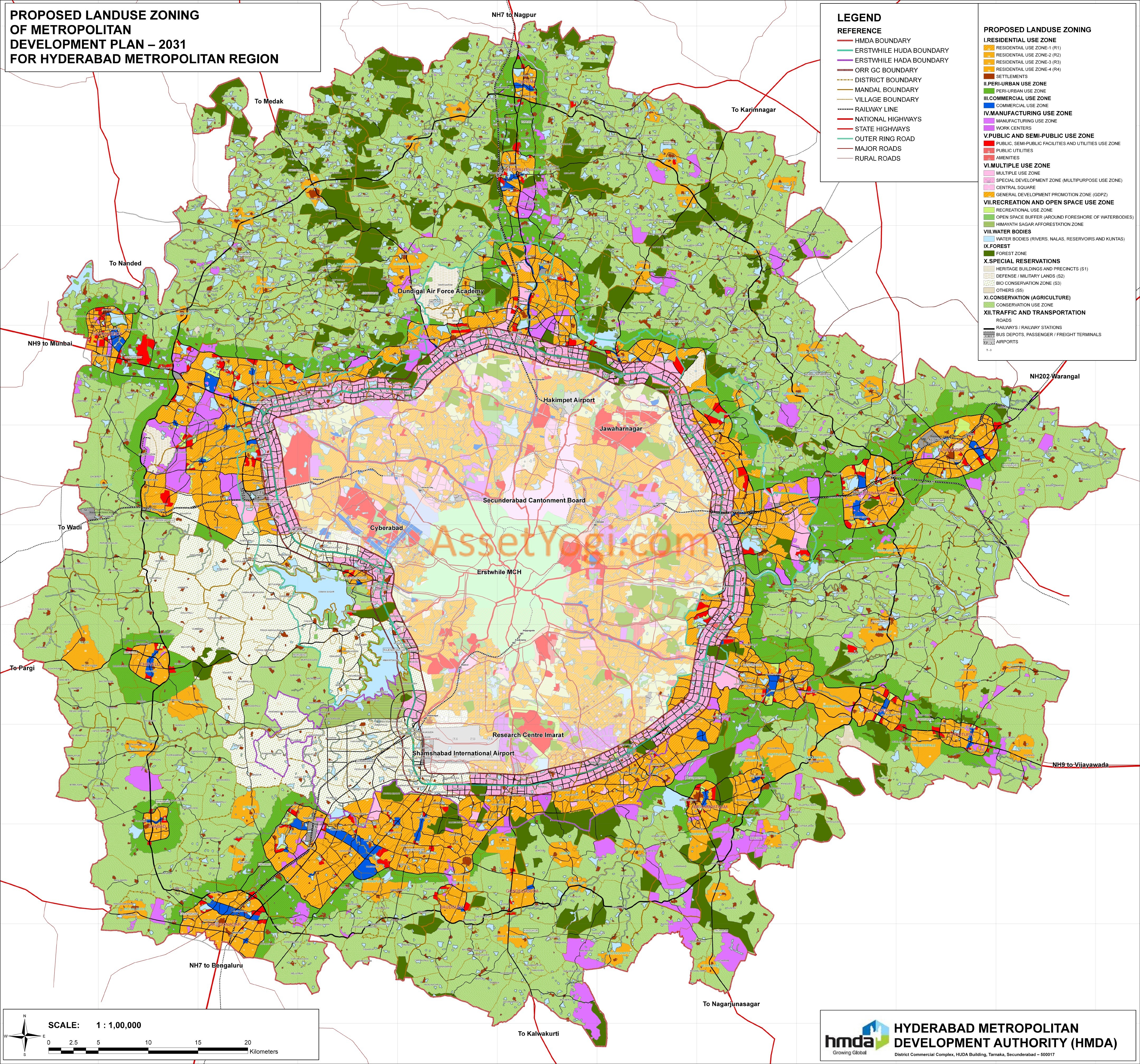
Hyderabad Master Plan 2031
Area Covered
The Hyderabad Master Plan 2031 for Hyderabad Metropolitan Region covers an area of around 5965 Sq.Kms., which consists of:
- Extended area of HMDA of 5018 Sq.Kms.
- Areas covered by Outer Ring Road Growth Corridor i.e., 1 Km belt on either side of ORR (330 Sq.Kms) earlier notified vide G.O.Ms.No.470 MA dt:09.07.2008.
- Areas covered by Part of Erstwhile HUDA Area outside Outer Ring Road Growth Corridor (432 Sq.Kms) earlier notified vide G.O.Ms.No.288 MA dt:03.04.2008.
- Portions covered by Part Hyderabad Airport Development Authority Master Plan, outside Outer Ring Road Growth Corridor (185 Sq.Kms) earlier notified vide G.O.Ms.No.287 MA dt:03.04.2008.
- Areas covered by Master Plan for Bhongiri earlier notified vide G.O.Ms.No.242 MA dt:11.05.1989.
- Areas covered by Master Plan for Sangareddy earlier notified vide G.O.Ms.No.32 MA dt:12.01.1988.
The Hyderabad Master Plan 2031 (HMDA Master Plan 2031) envisages a population of 184 lakhs by 2031, work force of 65 lakhs, the present trends of developments, the Inner Ring Road, the Outer Ring road and radial roads.
The HMDA master plan 2031 of hyderabad has proposed a radial-concentric structure of development with new urban nodes and urban centers in all directions to promote balanced development in the Hyderabad Metropolitan Region with a Peri Urban Zone all along the urban area, hierarchy of circulation network to cater to the present and future travel needs of population and activities.
Types of land development permitted:
Unless and otherwise stated or exempted by the Metropolitan Commissioner, HMDA land assemblage and development would be promoted, facilitated and approved in any of the following manner.
- Land Pooling or Area Development Schemes.
- Layout development Schemes
- Group Housing Schemes
- Group development schemes
- Township development
- SEZ development
- Development Schemes & Special Projects under the HMDA Act,2008
- Individual plot sub-division /individual plot or plots Amalgamation
Application through Licensed Developer Mandatory:
- Land for development for a, d, e, f & g shall be permitted only in case such a Scheme or project is undertaken through a licensed developer.
- Land assemblage scheme/ layout development may be permitted for residential, commercial, industrial, institutional, recreational, truck terminal/traffic node and other activities like SEZ, Corporate Townships, Integrated townships development, Special Projects and the like, subject to the compliance of these regulations and development specifications.
- Individual plot sub-division/Amalgamation would be allowed only in case of plots forming part of approved Land Pooling Schemes or layouts approved by the Metropolitan commissioner.