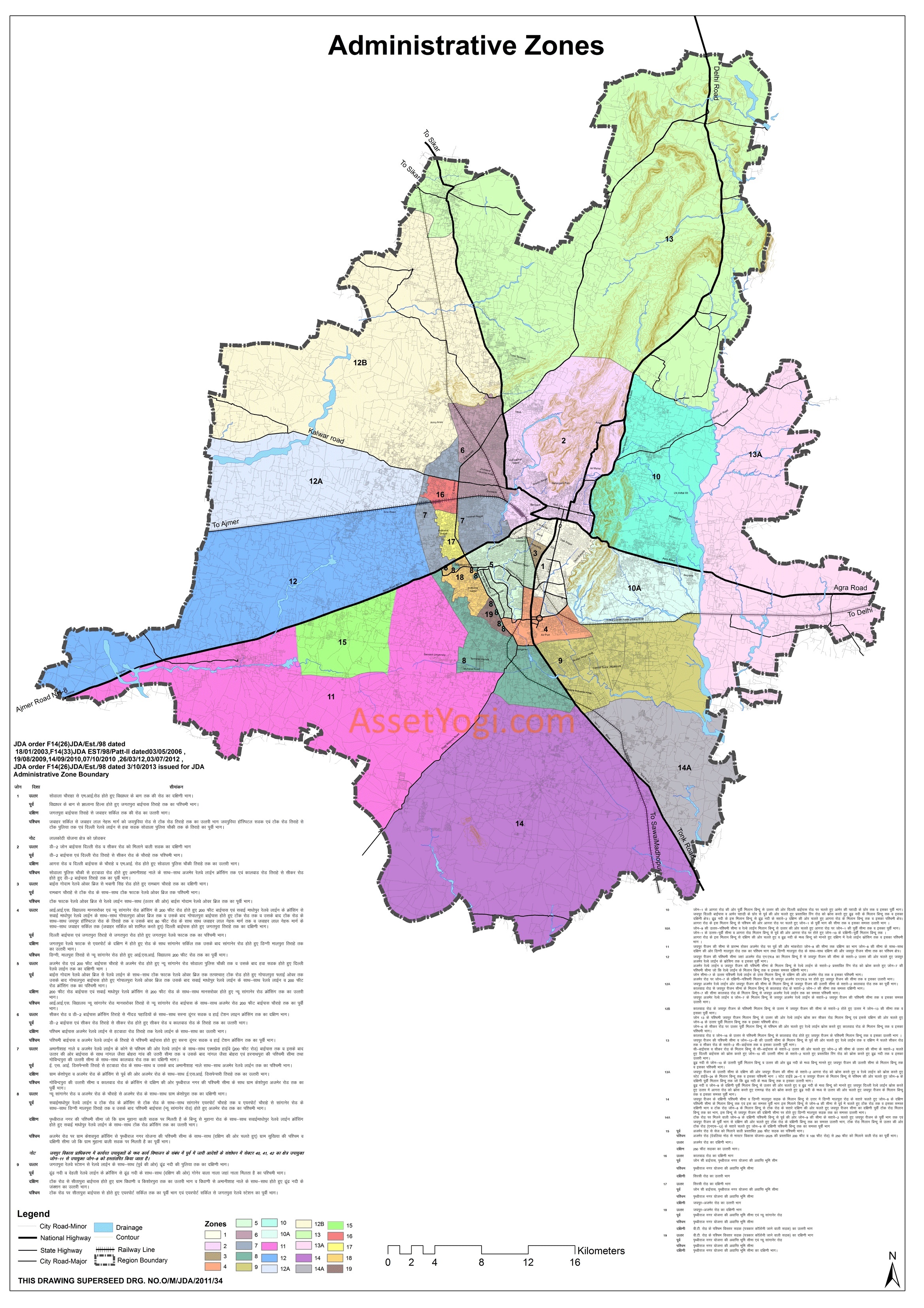
JDA Jaipur Master Plan 2025 has been prepared to provide vision & regulations for development and building activity in the Jaipur Region of Rajasthan. It envisages a population of approx. 65 lakhs in Jaipur city and a total of 75 lakhs including satellite towns by 2025. Accordingly, 2940 sqkm of land is allocated under the proposed land use by 2025 in Jaipur master plan.
JDA Master Plan 2025 for Jaipur has 5 volumes. You can download these volumes including all maps from here. You can go through the Summary of JDA Jaipur master plan 2025, in case you don’t want to go through the complete master plan. To share your opinions and suggestions, please use the comments section at the end.
Downloads
Volume 1 – Jaipur Region Existing Profile
Volume 2 – Development Plans
Vol 3 – Development Plans for Satellite Towns & Growth Centres
Volume 4 – Development Promotion & Control Regulation
Volume 5 – Map Book
Summary – JDA Jaipur Master Plan 2025
Introduction
Jaipur is probably the first planned city of Modern India. Its features of beautiful Architecture, planned growth and cosmopolitan character have endowed it with uniqueness in India’s urban setting. Jaipur being capital of Rajasthan is the focus of the socio-economic and political life of State. It witnessed fast physical and demographic growth. With 2001 population at 23.23 lakhs, the city is likely to attain a population of 64.95 lakhs by the year 2025 with 5.3% annual growth rate.
Strategically located, with the capital of India, Delhi at 258 kms and Agra at 232 kms, the city forms part of the famous Golden Triangle. It is also located on the golden quadrilateral of National Highway Development Programme. The locational advantage of the city as also it being a famous tourist destination, has boosted the growth of the city over the years with many new developments and projects coming all over.
The image, Jaipur city offers, at national and international levels, needs a special attention at planning front to make it a world class city. An inclusive planning, upgradation of physical infrastructure, provision of basic amenities, various housing options and preservation of natural environs, will help Jaipur to portray a world class image in the coming years.
Master Development Plan 2009-2025 (JDA Jaipur Master Plan 2025) envelopes 2940 square kilometers consisting 725 villages, one Municipal Corporation and 2 Municipal Councils.
Population Projections
| Year | 1991 | 2001 | 2011 | 2021 | 2025 |
| Jaipur U.A. | 1518235 | 2322575 | 3602000 | 5419208 | 6495000 |
| Growth Rate (%) | 49.56 | 52.98 | 55.06 | 50.44 | 49.64 |
| Development Nodes within the Region by 2025 | |||||
| Chomu | 38523 | 50708 | 65583 | 82727 | 90250 |
| Morija | 9335 | 11363 | 14204 | 17755 | 19530 |
| Jaitpura | 4319 | 5679 | 7496 | 9895 | 11162 |
| Anatpura | 3802 | 5044 | 6658 | 8789 | 9913 |
| Bagru | 15509 | 22092 | 29842 | 39120 | 43243 |
| Dahmi Kalan | 3359 | 4442 | 6219 | 8706 | 10099 |
| Bassi | 15135 | 19888 | 26252 | 35924 | 41241 |
| Kalwar | 4411 | 6478 | 9525 | 13998 | 16798 |
| Pachar | 3414 | 4444 | 5777 | 7510 | 8411 |
| Achrol | 9295 | 12796 | 17658 | 24369 | 28073 |
| Kukas | 2216 | 2947 | 4244 | 6111 | 7186 |
| Bhanpur Kalan | 3662 | 4370 | 5244 | 6555 | 7342 |
| Chonp | 3602 | 4909 | 6799 | 9417 | 10867 |
| Bagwara | 3177 | 4190 | 5531 | 7301 | 8235 |
| Jahota | 4983 | 4996 | 6745 | 9105 | 10380 |
| Jamwa Ramgarh | 5815 | 6638 | 8231 | 10207 | 11186 |
| Shivdaspura & Chandlai | 6779 | 8837 | 9751 | 11028 | 11534 |
| Kanota & Heerawala | 6968 | 8838 | 9793 | 11158 | 11705 |
| Watika | 6537 | 8292 | 9237 | 10343 | 10785 |
| Rest of the villages ^ | 313540 | 526864 | 590126 | 669027 | 700584 |
| Population of 243 villages* | 178755 | ||||
| Total | 2161371 | 3044946 | 4445298 | 6416419 | 7561604 |
* – The population of these villages has been depicted for the year 1991 to arrive at the comparable population.
^ – 532 villages
As per the above table, JDA Jaipur Master Plan 2025 has been planned for a population of approx. 65 lakhs in Jaipur city and a total of 75 lakhs including satellite towns by 2025.
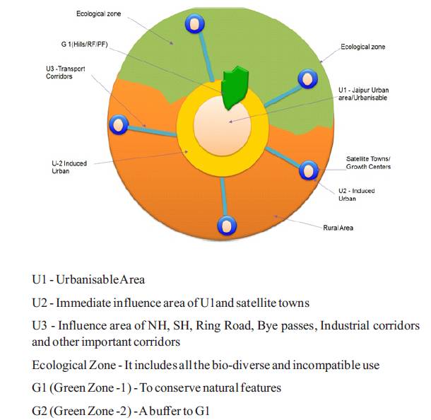
Urbanisable Area
The rapid urbanization of the growth of boundary less cities are a new paradigm of the growing cities and Jaipur is no exception. Area abutting the planned areas always remain under pressure for new avenues due to close proximity and easy accessibility taking into account the environmental consideration, physiographic existing development, directions of growth, requirement of land to accommodate the expected increase of population development already taken place and other activities.
Thus the Master Development Plan – 2025 (JDA Jaipur Master Plan 2025) has been drawn up with reference to the following five policy zones:
- U1 – Urban Area 1
- U2 – Urban Area 2- U2
- U3 – Urban Area 3 – U3
- G1, G2 – Ecological Zone
- Rural Area
With an objective of development of Jaipur Region and attract investment opportunities, new concept for development of Jaipur region is drawn as mentioned above. It would help Jaipur to become a national hub of economic activities and a mega city generator of economic momentum for global exchange and which further places the capital city to a position of global competitiveness.
Urban Area -1 (U1)
U1 is the compact urban area place which serves as nuclei of development.
Urban Area-2 (U2)
U2 will be the immediate influence area on periphery of U1 area to accommodate special area projects and other developments. U1 is divided into Low Intensity Zone (LIZ) – the U2 area overlapping with G2 area and High Intensity Zone (HIZ) – rest of U2 area.
Urban Area-3 (U3)
U3 will be the continuum to U1 and U2 area on either side of major roads – National Highways, State Highways, Ring Road, Bye Passes, Industrial Corridors and other important corridors. This is generally 100 meter buffer on either side of NH and 500 m on either side of SH excluding road right of way. Like U2, U3 will also have LIZ and HIZ.
Ecological Zone
Eco-sensitive areas which includes Rivers, ponds, reserve/ protected forests, hills etc. Ecological Zones are further divided in Green Zone -1 (G1) and Green Zone-2 (G2).
- Green Zone – 1 (G1) – A zone where the principal aim is to conserve natural features such as hills, rivers, nallahs, water bodies and forest, flora & fauna, at any cost. The zone is strictly reserved and to be protected from any development.
- Green Zone-2 (G2) – G2 is primarily the area abutting G-1. This is developed as a buffer to promote a continuum to G-1. Part of G2 will include Ecological Area which will be suitable for agriculture and other eco-sensitive purposes.
Rural Area
The whole area minus the area which is not covered by the urbanisable area (U1, U2, U3) and Ecological Zone is Rural Area.
The concept of U1, U2, U3, G1, G2 and Rural areas in JDA Jaipur Master Plan 2025 is explained in the following diagram:
Land Utilization
Land Utilization as per MDP-2011 and MDP-2025:
| Use | Master Plan 2011 | Master Plan 2025 | ||
| Area (Sq.Km.) | Percentage | Area (Sq.Km.) | Percentage | |
| Urbanisable Area | 391 | 19.94 | 1596 | 54.30 |
| Ecological Area | 481 | 24.55 | 894 | 30.40 |
| Rural Area | 1087 | 55.51 | 450 | 15.31 |
| Total | 1959 | 100 | 2940 | 100 |
Land Utilization of Jaipur Region:
| JDA Jaipur Master Plan 2025 Area | |||||
| Area Category | Zone | Area (Sq.Km.) | Area (Sq.Km.) | % Area | |
| Urban Area (Jaipur Region + Satellite Towns) |
U1 | 954 |
1596 |
54.3 |
|
| U2 | HIZ | 391 | |||
| LIZ | 116 | ||||
| U3 | HIZ | 96 | |||
| LIZ | 39 | ||||
| Ecological Zone | G1 | RF/PF/Hills | 224 |
894 |
30.4 |
| Drain/ River/ Waterbody | 57 | ||||
| G2 | Buffer to G1 | 196 | |||
| Ecological Area | 417 | ||||
| Rural Area | 450 | 450 | 15.31 | ||
| Total | 2940 | 2940 | 100 | ||
Transportation
Bus Terminals:
Provision of five Bus terminals regular intervals, at:
- south of Niwaru Road at the periphery
- south of Kalwar Road at the periphery
- the extended Sirsi road near Nimera
- south of Delhi Railway Line near Khatipura Railway Station
- the intersection of Jawahar Nagar Byepass with Shanti Path
MRTS & BRTS:
Provision of Metro and BRTS to encourage public transportation and improve accessibility while reducing time and cost expenses.
Ring Road:
The ring road development corridor is a visionary plan to create infrastructure through public participation to meet the rapid growth and better connectivity bypassing the heavy traffic coming into the city.
The project involves development of a 360 , with expressway, service roads and a public transportation route along with area for P.A.P (projected affected persons). It includes two alignments covering Jaipur urban areas i.e. northern alignment and southern alignment.
Ghat ki Guni Tunnel:
Ghat-ki-Guni with heritage rich buildings on both sides, is the only eastern entry/ exit of Jaipur. It is accident prone. Traffic pollution is damaging the heritage in 2 km serpentine length of congested route with steep gradient. This is of concern to both Govt. of India and govt. of Rajasthan and this road is declared as Heritage Road (Transport Nagar Junction to Chulgiri crossing).
In order to protect this area being used as main thoroughfare, JDA embarked on a project of a Tunnel to route all heavy and light vehicles, with a tunnel length of 2800 M including 858 M Twin Tube Tunnel, interconnected at two locations.
Satellite Towns/ Growth Centres
In order to have balanced regional development, Master Plan is prepared for 11 satellite towns and 4 growth centres within the Jaipur region. These satellite towns will help in reducing migration and urban infrastructural pressure to the mother city. Development of these towns will encourage economic development thereby creating job opportunities for the town and the villages in the vicinity.